Wednesday, January 9, 2013

1793 Aitken: Plan of York Harbour Surveyed by Order of Lt. Gov. Simcoe

‘Alexander Aitken (died 1799) was the son of a land surveyor in Berwick-upon-Tweed, England. He emigrated to Canada and was appointed a Deputy Surveyor in 1784. He prepared one of the first proposals for a town at Toronto for Lord Dorchester and later did many general surveys and maps, including the survey of the Town of York [below] for Lieutenant-Governor Simcoe.

This map shows the earliest known plan of the Town of York. The 10-block "Old" town was laid out in 1793 on a site selected by Simcoe in the eastern part of the lands reserved for government and military use. Part of the first concession of York Township north of the township baseline (Queen Street) is also shown in its original form, before creation of the park lots.

Aitken surveyed the harbour and peninsula, and this map contains the first accurate depiction of the peninsula, the marsh, and the rivers and streams along the shoreline.’

- Isobel Ganton & Joan Winearls, MAPPING TORONTO'S FIRST CENTURY 1787-1884

The soundings for this map were taken by Joseph Bouchette.

Click the image to view a full-size version.

Map: 1793 Plan of York Harbour Surveyed by Order of Lt. Gov. Simcoe, by Alexander Aitken

Plan of York Harbour Surveyed by order of Lt Govr Simcoe [Sgd] by A. Aitken. D [Syr?] 179[3]
Image courtesy The National Archives of the UK: CO 700 Canada no.60.
Winearls, MUC no. 2015

Digital Repatriation
The Aitken map was sent by John Graves Simcoe along with a letter he dispatched to Henry Dundas, Secretary of State for War (and the Colonies) in 1793. We—Canada—never got the map back; the original is held by the UK National Archives in their holdings of British military correspondence. As a result few Canadians have ever seen this version in its entirety, in colour; locally, only transcript copies have been available—until now.

Thanks to the generous support of Angie and Jeff Hocking (and their friends), I was able to obtain the above scan, and 'repatriate' this significant piece of Toronto’s history. I am very pleased to present it to you for general use and inspection.

Thanks Angie & Jeff for the help!

Here’s an transcripted excerpt from Simcoe’s letter (map reference highlighted):


Image courtesy TPL: Correspondence of Lieut. Governor John Graves Simcoe (Vol. 2, p58)

Other copies [the 'local' versions]:
The version below is a copy that was specially prepared for John Ross Robertson’s Landmarks of Toronto. It’s useful for sussing out the details of the map which may be faded on the original.

Click the image to view a full-size version.

1793 Aitken Plan of York Harbour

Courtesy of Toronto Public Library: T1793/4Mlrg. Coloured manuscript; 1 inch to 20 chains.

Another version, a transcript copy:
Click the image to view a full-size version (3MB).


Image courtesy TPL.

A photo of the plan as it appears in the Correspondence of Lieut. Governor John Graves Simcoe (Vol. 2, p57):


See also University of Toronto photostat & this other copied Plan of York Harbour by Aitken (note D and E no longer in References).

Please ‘Like’ and Share these maps with other Toronto history enthusiasts! (+1s are also welcome!)

1872 Wadsworth & Unwin Map of the City of Toronto - Tax Exemptions

‘The coloured additions to this map show the land exempt from taxation in Toronto in 1878. The table in the upper right corner [of the 3rd panel] indicates the total assessed value of exempt property - one-seventh of the value of all city property. Below this is the legend which indicates categories of exempt land. Note the high proportion of church property.

The most hotly disputed category of exempt land was "lawns and gardens", which included all land not used for urban purposes. Although not coloured on the map, this category included the unsubdivided lands of the northwest part of the city. The exemption was criticized for blocking development and lowering tax revenues. By 1880 new legislation decreed that lawns and gardens would be taxed as urban land and within a few years much had been subdivided and offered for sale.’

- Isobel Ganton & Joan Winearls, MAPPING TORONTO'S FIRST CENTURY 1787-1884

Click the images to view full-size versions (2-3MB, PDF).

1872 Wadsworth & Unwin Map of the City of Toronto showing Tax Exemptions - W

1872 Wadsworth & Unwin Map of the City of Toronto showing Tax Exemptions - C

1872 Wadsworth & Unwin Map of the City of Toronto showing Tax Exemptions - E


Wadsworth & Unwin’s Map of the City of Toronto [shewing real estate exemptions from taxation], compiled and drawn by Maurice Gaviller, C.E. & P.L.S., from plans filed in the Registry Office and the most recent surveys, 1872. Wadsworth & Unwin, P.L. Surveyors, Toronto, Sepr. 1st, 1872. City Engineers Office, Toronto, Jany 1878 [Signature illegible]. Copp, Clark & Co. Lith. Toronto. Entered according to Act of the Parliament of Canada, in the year 1872, by Wadsworth & Unwin, in the Office of the Minister of Agriculture.

Lithograph with coloured manuscript additions; 1 inch to 300 feet
Images courtesy Library and Archives Canada: NMC25641

Advertisement, 1871 City Directory
‘Vernon Bayley Wadsworth (1842-1940) and Charles Unwin (1829-1918) were prominent surveyors in Toronto in the latter half of the century. Both were pupils of J.S. Dennis. They were in partnership from 1868 to 1876 when Wadsworth left the firm to work for the London and Canadian Loan and Agency Company.

Unwin also held the position of an Assessor for the City from 1872 to 1905, when he was appointed City Surveyor. The firm from which he retired in 1896, Unwin, Murphy, and Esten, is still in existence today.’

- Ganton/Winearls, ibid.

Please ‘Like’ and Share these maps with other Toronto history enthusiasts! (+1s are also welcome!)

Tuesday, January 8, 2013

1878 Illustrated Historical Atlas of the County of York

York County Atlas cover featuring a lovely detailed Royal Coat of Arms
of the United Kingdom. Click to expand view.
‘Between 1874 and 1881, approximately forty county atlases were published in Canada, covering counties in the Maritimes, Ontario and Quebec.

Each of the county atlases consisted of a historical text, township and town maps, portraits, views and patrons' directory / business cards. But more important, names of residents were marked on the lots of the township maps in these county atlases [emph. mine]... All of these atlases were sold by subscription. Prominent county residents paid an additional sum to have biographical sketches, portraits and views of their residences or businesses included in the atlases.’

- In Search of Your Canadian Past: Canadian County Atlas Digital Project

‘Illustrated historical atlas of the county of York and the township of West Gwillimbury & town of Bradford in the county of Simcoe, Ont. Toronto: Miles & Co., 1878.’

The following three maps show, respectively, the South West, South East, and North sections of York from the 1878 York County Atlas. Images of York courtesy McGill University. [The fourth map of Toronto courtesy TPL]

While most names are omitted in the core of the city, these maps nevertheless contain exceedingly valuable insights into who owned specific parcels of land in the suburbs.

Click the images to view full-size versions (6+ MB).

South West Part of York
South West Part of York, 1878 Historical Atlas of the County of York

South East Part of York
SE Part of York, 1878 York County Historical Atlas

York - North
Map: North Part of York, 1878 Historical Atlas of the County of York

Toronto

Map of Toronto, published by Willing & Williamson
Drawn by A.T. Cotterell, C.E. Toronto.
Revised by H.J. & W.A. Browne, P.L.S. Toronto to April 1, 1878
Image courtesy Toronto Public Library: T1878/4Msm
See also: LAC MIKAN 4170046

The above map is identical to the map that appears on p. 10-11 of the Illustrated Historical Atlas, with two differences: No page numbers, and this map says 'Published by Willing & Williamson' instead of 'Published by Miles & Co. Map & Atlas Publishers, Toronto'

For additional maps of York County from the York Historical Atlas, please check out the Canadian County Atlas Digital Project. This excellent project contains information and maps from almost all of the historical Ontario county atlases described above.

Be sure to check out the maps for ‘Scarboro’ and Etobicoke too! [Note: large files!]

Please ‘Like’ and Share these maps with other Toronto history enthusiasts! (+1s are also welcome!)

1834 Chewett City of Toronto and Liberties

This is the ‘first’ official map of the City of Toronto. [See also 1834 Bonnycastle/Tazewell City of Toronto: The Capital of Upper Canada]

‘In [March] 1834 the City of Toronto was incorporated with boundaries extending far beyond those of the old Town of York. The city was divided into five wards: St. Patrick's, St. George's, St. David's, St. Lawrence, St. Andrew's. Liberties were attached to each ward for the growth of the ward or the creation of new wards. The boundaries of the city and liberties were the present Dufferin Street on the west, Bloor Street on the north, the Don River on the east including the area south of today's Queen Street, east to the far side of Lot 3 (now MacLean Avenue), and the lake on the south. This map shows the area from the waterfront north to the top of the 1st concession and from Lot 1 to the Humber River.’


‘On April 22, 1834, Council agreed to petition His Excellency Sir John Colborne, Lieutenant Governor, to arrange to have a plan drawn up of the new City of Toronto, its liberties, and its harbour, showing its division into wards and the relative connection of its limits with adjacent township lands.

Samuel Proudfoot Hurd, Surveyor General, was duly placed in charge of the request, and James Grant Chewett of his office was assigned the actual task of preparing the plan. The completed plan, dated June 24, 1834, was presented to Council July 3, 1834.’

- City of Toronto Archives, Toronto in 1834.

Click the image to view a full-size version.


City of Toronto and Liberties, by J.G. Chewett, 1834. (This is a John Ross Robertson transcript copy - Note how 'S.P. Hurd S.G.' has been mis-transcribed).
Image courtesy Toronto Public Library: MsX.1918.1.3. Winearls, MUC no. 2065 (2)

The numbered line at the top of the map is what later became Bloor St. (2nd Concession line)

The plan shown below is a copy of the original 1834 map, prepared by Wadsworth & Unwin, Provincial Land Surveyors, and dated April 1, 1871. There are a few minor differences: the mouth of the Don river, as well as the outlines of several structures in the west of the core.

Click the image to view a full-size version (3 MB).

1834 Plan of the City of Toronto and Liberties, JG Chewett

Plan of the City of Toronto and Liberties, J.G. Chewett. 20 Chains to an Inch
Image courtesy City of Toronto Archives (see note below).

‘James Grant Chewett (1793-1862) was the son of William Chewett, an important early surveyor. James Chewett became a deputy surveyor in 1819, and was mainly employed in the Surveyor-General's office, serving as Deputy Surveyor-General from 1832 to 1841. He prepared several plans of Toronto and an important map of Upper Canada for the Canada Company in 1826. He retired from government service in 1841 and later became president of the Bank of Toronto.’

- Isobel Ganton & Joan Winearls, MAPPING TORONTO'S FIRST CENTURY 1787-1884

This 2nd map took some effort to assemble!

The City of Toronto Archives has it posted online: MT401. Unfortunately, they present the file using a horrible Adobe Flash widget called ‘Zoomify’. It’s wretched. Please, IT folks, give us the file in an open format (as an option)!

I have nevertheless managed to liberate the 1834 Chewett (1871 Wadsworth) map from the Flash file and present the scan above in its entirety for examination. Hurrah for dogged persistence!

Celebrating Incorporation of Toronto 1834 formerly Muddy York
ca. 1909 by Frederic Waistell Jopling
See Also
1827 JG Chewett Plan of the Town of York
1834 Bonnycastle/Tazewell City of Toronto: The Capital of Upper Canada

Please ‘Like’ and Share these maps with other Toronto history enthusiasts! (+1s are also welcome!)

1902 Sankey Plan of the City of Toronto

‘The post of City Surveyor, left vacant in 1854 by the resignation of Mr. Howard, was not filled until Dec. 24th, 1888, when Mr. [Matthew] Villiers Sankey received the appointment. Mr. Sankey was born at Brookeboro, County Fermanagh, Ireland, Oct. 3rd, 1854: educated at Portora Royal School, Enniskillen, and in 1872 passed his examinations for the India Civil Service.

On coming to Canada he entered the firm of Wadsworth, Unwin & Brown, afterwards becoming a partner. Mr. Sankey, who laid out the new rifle ranges in Toronto, was an authority on military matters, and supplied the Government with special maps, particularly of the Toronto and Niagara districts. He was a major in the Queen's Own Rifles: commanded the Corps of Guides. Resigned his post as City Surveyor, Jan. 20th, 1905. On July 10th, of that year, while engaged on engineering work near Kenora, Mr. Sankey met death by drowning.’

- Landmarks of Canada: What Art Has Done for Canadian History, A Guide to the J. Ross Robertson Historical Collection

Villiers St., just north of Commissioners St., was named after Sankey.

Click the image to view a full-size version (4 MB).

1902 Plan of the City of Toronto, signed by Villiers Sankey, City Surveyor

Plan of the City of Toronto, Signed by Villiers Sankey, City Surveyor, 1902

Map courtesy U of T Map and Data Library: G3524 .T61 1902


Please ‘Like’ and Share these maps with other Toronto history enthusiasts! (+1s are also welcome!)

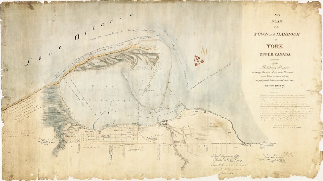
1833 Bonnycastle: No.1 Plan of the Town and Harbour of York Upper Canada

RH Bonnycastle
‘This reconnaissance plan is rich in information about the surroundings of the town and the peninsula. By 1833 Fort York was in such disrepair that new fortifications to the west were planned as shown here. Note the horse-powered ferry operating between the docks and the peninsula. The Lawyer's Hall at Lot (Queen) Street and College (University) Avenue is the present Osgoode Hall.

Several plans made in the 1830s, including this one, were oriented to the south, probably under the influence of military map-makers whose attention was always focused on the harbour and its defense.’

- Isobel Ganton & Joan Winearls, MAPPING TORONTO'S FIRST CENTURY 1787-1884


Click the image to view a full-size version (PDF).

1833 Bonnycastle No.1 Plan of the Town and Harbour of York

No. 1 plan of the town and harbour of York Upper Canada and also of the Military Reserves showing the site of the new barracks and work around them, as proposed to be erected near the Western Battery.
Royal Engineer Office York U. Canada 31st Octr 1833 (Signed) RH Bonnycastle Captn Royl Engrs Senr Off. Western District U.C. E.J. Ford Lt Royal Engineers Decr 5th 1833 Gusts Nicolls Colonel Comg R Engineer Canada.

Image courtesy Library and Archives Canada: NMC 16818. Winearls, MUC no. 2063 (2)

‘Sir Richard Henry Bonnycastle (1791-1847) was the son of a professor of mathematics at the Royal Military Academy. He was in command of the Royal Engineers in Upper Canada at Kingston from 1837 to 1839 and was knighted for his services during the Rebellion. He was the author of several books about Canada and an amateur painter. [Bonnycastle was also the father of Henry William John Bonnycastle, who drew a related map in 1834. -N.]’
- Ganton/Winearls, ibid

This next version is a copy submitted to Ottawa in 1907.

Click the image to view a full-size version.

1833 Bonnycastle No.1 Plan of the Town and Harbour of York Upper Canada

Lt.-Col. Gustavus Nicolls


Image courtesy TPL: T1833/4Mlrg.

Lieutenant-Colonel Gustavus Nicolls commanded the Corps of Royal Engineers in Canada from 1815 to 1837, and was responsible for the 1816 Nicolls & Duberger Plan of the Fort at York Upper Canada.


Please ‘Like’ and Share these maps with other Toronto history enthusiasts! (+1s are also welcome!)

1851 JO Browne Map of the Township of York

Ad for Browne’s map via
Rowsell’s 1850 city directory 
‘The early 1850s were a time of general prosperity and rapid growth. Hoping for quick profits, speculators bought. and sold land, subdivided and resubdivided lots. This land "boom" flourished until 1857, when the market collapsed.

The maps made during the boom years reflect the commercial enthusiasm of the times in many ways. They were produced to advertise property for sale, to promote the city, and to record new subdivisions. The map-makers themselves were no longer primarily civil servants or military engineers, but provincially licensed surveyors who ran their own businesses. In addition, this map was printed locally, an indication that the printing industry in Toronto had come of age.

York Township had more forest in 1851 than most townships. The delay in clearing the land was due in part to the number of lots held as investments by prominent Toronto families. In addition, the ravines of the extensive river systems made many areas difficult to farm.

Note that more township road allowances had been opened, while many early roads that did not follow the grid system had disappeared. Many villages, all later absorbed into the metropolitan area, had sprung up on the outskirts of the city.’

- Isobel Ganton & Joan Winearls, MAPPING TORONTO'S FIRST CENTURY 1787-1884


Click the image to view a full-size version (7 MB).

Map of the Township of York, by J.O. Browne

Map of the Township of York in the County of York Upper Canada. 1851. Compiled and Drawn by J.O. Browne FSA. Civil Engineer & D.P. Surveyor. Toronto. Engraved and Printed b Jno Ellis, 8, King St.

Original image scan courtesy City of Toronto Archives: Series 443, File 40. Winearls, MUC no. 2215

Large version liberated by W. Xavier Snelgrove.

‘John Ownsworth Browne (1808-1881), formerly a railway engineer in England, became a Provincial Land Surveyor in Toronto in 1848. He surveyed 50 subdivision plans in Toronto during the boom period and also produced and published several important general plans, such as the York township plan of 1851 and the compiled city plan of 1862. His son, Harry John Browne, worked with him initially and later went into the partnership of Wadsworth, Unwin, and Browne, later Unwin, Browne, and Sankey.’ - Ganton/Winearls, ibid.

Supposedly the TRL has a copy of this map (912.71354b68) which promises to be a lot less faded, but I have not been able to find it:


“This detail from an 1851 map of York Township shows the varied stages of development of the Park Lots nearly 60 years after they were first granted. The shaded yellow line enclosed the City of Toronto and Liberties—which in 1850 included the area from today’s Dufferin Street in the west to the Don River in the east, and from the Toronto Harbour north to Bloor Street. Only the most southerly 400 feet of the Park Lots 1 to 18 were within the actual city limits. The Liberties included Park Lots 1 to 28.”

- Ontario Genealogical Society, Simcoe’s Gentry: Toronto Park Lots

Please ‘Like’ and Share these maps with other Toronto history enthusiasts! (+1s are also welcome!)