Sunday, January 27, 2013

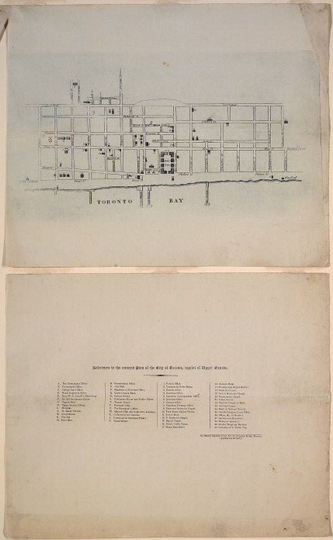
1834 Alpheus Todd Engraved Plan of the City of Toronto

Alpheus Todd ca.1867
Alpheus Todd (30 July 1821 – 22 January 1884) was an English-born Canadian librarian and constitutional historian, most notable for his publications on parliamentary government.

When he was still a young boy, his family emigrated to York, Upper Canada in 1833. The following year, York was incorporated as the city of Toronto. Todd -- at the precocious age of 13 -- produced the following Engraved Plan of the City of Toronto, by walking through the streets and converting his paces to a scale.

‘A member of the local legislature [prominent lawyer Robert Baldwin Sullivan. -N.] was so pleased with the lad’s intelligent pertinacity that he obtained a vote of the House to take copies of the map sufficient to pay the cost of engraving, and had him installed in a temporary capacity in the legislative library [viz., the library of the House of Assembly of Upper Canada. -N.], then a mere nucleus of a collection in a small room.’

- Editor’s Preface, Parliamentary Government in the British Colonies [Alpheus Todd] 

Todd’s stellar career as a librarian was thereby launched... But back to the map: it provides the location of over fifty assorted places of interest in the newly incorporated city. The copy seen below, held in the collections of the Toronto Public Library, is believed to be the only surviving copy. The TPL obtained the map via the Stephen A. Heward Family.

Could you draw such a map at 13?

Click the image to view a full-size version.  

1834 Alpheus Todd Engraved Plan of the City of Toronto

Plan of the City of Toronto, Capital of Upper Canada, by Master Alpheus Todd, No. 35 Newgate Street, Toronto, Opposite the Brewery, 1834.
Image courtesy Toronto Public Library: T1834/4Msm. Winearls, MUC no. 2067

Amusingly, the Brewery opposite which Master Alpheus lived does not appear to be marked on the map...

Gratuitous bonuses — images of the Town concurrent with the Map
Third Parliament Buildings, by J.G. Howard, 1834.
Front St. W., looking n.w. from Front & Simcoe Sts, labelled ‘S’ on Todd’s map:


Image courtesy TPL: JRR 826
Immigrant sheds are depicted extreme left (source). One of the white buildings in the distance is probably York Hospital -- next picture. See also: Nathaniel Currier—Parliament Buildings, 1835.

Pencil Sketch of Old Hospital, King St. W., n.w. corner John St. built in 1819, Unknown, 18??.
North west corner of King and John St., labelled ‘I’ on Todd’s map.


Image courtesy TPL: B 1-36b
Built ca. 1820, abandoned as a hospital in 1854, this building was also used as a meeting place for Parliament, 1824-1829.

Upper Canada College by Nathaniel Currier, 1835.
Labelled ‘H’ on Todd’s map.


Image courtesy TPL: JRR 3666 Cab II (See also: X 76-61 Cab II)

North side of King Street, Toronto to Church Streets by J.G. Howard, 1835


Image courtesy City of Toronto, Toronto Culture, Museums and Heritage Services 1978.41.40.[1970.114.19A]
K, U, L, J on Todd’s map. (Gaol, Fireman’s Hall, Courthouse, St. James’ church pre-steeple — Todd switched K, L)
See also: Thomas Young, King St. E., looking e. from Toronto St., 1835

Taylor’s Wharf, by J.G. Howard, 1835


Image courtesy City of Toronto Toronto Culture, Museums and Heritage Services, 1978.41.51.

The end of Taylor’s Wharf at the foot of Frederick, looking east. Far right is William Gooderham’s Windmill -- before the distillery was added [Both Taylor’s Wharf and the Windmill may be found on Todd’s map]. To the west of it, one of these structures may be Gooderham’s first house.

[See also...]

Toronto, 1834. Shewing the East End of Toronto, the Marsh, and Gooderham’s Windmill


Image courtesy Toronto Public Library: B 3-20a

After a lithotint, ca 1877 (979-19-1), which in turn is after a view of Toronto in 1835 drawn by Thomas Young and published by N. Currier in 1835 (x 24-1).

The Windmill is indicated bottom right in Todd’s map.


One More Extra Fun Bonus
This imaginative rendering of the City of Toronto in 1834 was probably created to celebrate the 100th anniversary of the City's incorporation in 1934. Though I can’t vouch for the accuracy of the sketch, it is quite entertaining to compare the notations with those of Todd’s map.

Click the image to view a full-size version. 


City of Toronto in 1834 by E.G.A. Foster ca. 1934
Image courtesy City of Toronto Archives: MT 00063

Please ‘Like’ and Share these maps with other Toronto history enthusiasts! (+1s are also welcome!)
1874 Hart & Rawlinson City of Toronto with Fire Limits

‘Fire protection by-laws regulated the construction materials and methods that could be used in the central area of the city. By 1874 three levels of regulation, as shown here, were in use. Property owners could petition to have their street included in a stricter regulation zone in order to prevent the building of poor-quality houses. (Note the extensions to limit B, shown in yellow). Such streets were usually already the preserves of the affluent, so this practice produced a type of zoning based on status.

In contrast to the hundreds of building by-laws of today, the fire protection by-laws were the only restriction on building in Toronto during its first century.’

- Isobel Ganton & Joan Winearls, MAPPING TORONTO'S FIRST CENTURY 1787-1884


Also observe the notation regarding how street numbering worked.

See also: Goad’s Atlas of Toronto -- Online! [In particular, see Plate 2 of the 1889 Insurance Plan for a detailed listing of fire district building criteria.]


Click the image to view a full-size (2MB) version. 

1874 Hart & Rawlinson City of Toronto with Fire Limits overlay

City of Toronto Compiled from Surveys made to the present date 1874.
Published by Hart & Rawlinson, Toronto. Lithograped & Printed by Copp Clark & Co. Toronto. 1874.
Coloured lithograph; 1 inch to 800 feet. Image courtesy Toronto Public Library: T1874/4Msm c2
Compare zones to: 1866 - LAC NMC 25145

Please ‘Like’ and Share these maps with other Toronto history enthusiasts! (+1s are also welcome!)

Saturday, January 26, 2013

1876 Gascard City of Toronto Bird’s Eye View from the Northern Railway Elevator

This lovely and charmingly detailed bird’s eye view shows the dominance of the railway system along Toronto’s waterfront.

“The railway and the harbour, both of which had such a great impact on the commercial and industrial economy of the city, were highlighted in later 19th-century views, such as that by G. Gascard in 1876.

The harbour and rail system had become a source of pride, symbolizing the city's growth and progress. Gascard's aerial view depicts at least six trains at the foot of the city and more than fourteen ships in the harbour. Buildings such as the churches and educational institutions that were so important in views before are still evident, but are secondary to the railways and harbour. The popularity of this image was reflected in its use as the mast-head for a Toronto newspaper [The Toronto Advertiser, in 1878. -N.].”

 
Click the image to view a LARGE version. 

1876 Bird’s Eye View of Toronto from the Northern Railway Elevator, lithograph by G. Gascard

City of Toronto Bird’s Eye View from the Northern Railway elevator, 1876
Drawn by G. Gascard (fl. 1873 - 1877).
Lithograph on wove paper, printed by Alexander Craig, Toronto.
Image courtesy Toronto Public Library, TRL, J. Ross Robertson Collection, JRR 745.

Here is the numbered key to the map:

1. Northern Railway shops.
2. Northern Railway offices, n.w. corner Brock and Front.
3. Knox College.
4. University of Toronto.
5. St. George's Church.
6. St. Patrick's Church.
7. Foot of Windsor St. (now Railway freight yards).
8. Grand Trunk Railway round house on esplanade.
9. Toronto Water Works.
10. John St.
11. Government House.
12. Parliament Buildings.
13. Osgoode Hall.
14. St. Michael's Cathedral.
15. Metropolitan Church.
16. Union Station.
17. St. James' Cathedral.
18. St. Lawrence Hall.
19. Old City Hall.
20. Old Great Western Station.
21. Yonge Street wharf.
22. York Street Wharf.
23. Grand Trunk Railway Elevator.
 
Alexander Craig was a printer located at 13 Adelaide East.

This map was printed with vignettes of commercial businesses around the edges, similar to the 1876 Gross Bird’s Eye View and the 1851 Fleming Topographical Map of Toronto. [The copy at the Archives of Ontario apparently includes these vignettes]

A miniature, slightly altered version of the map was used in this 1884 'Semi-Centennial Celebration' souvenir brochure:


and again for this 1896 brochure (20 years on!):


Images courtesy Toronto Public Library. Sources: 1st2nd

For comparison, check out this (unfortunately somewhat obscured) 1870 photograph from the same vantage point (atop the Northern Railway elevator):


Toronto harbour ca. 1870. View from Northern Railway Elevator, foot of Spadina Ave., looking east past Grand Trunk Railway wharf and elevator
Image courtesy Toronto Public Library: B 12-20b

See Also [Bird’s Eye Views]
1870 Canadian Railway News Bird’s Eye View of Toronto
1876 PA Gross Bird’s Eye View of Toronto
1886 Wesbroom: City of Toronto [Bird’s Eye View]
1892 Toronto Railway Company Map Shewing Toronto Street Railway Lines
1893 Barclay, Clark & Co. Bird’s Eye View Chromolithograph
  
Please ‘Like’ and Share these maps with other Toronto history enthusiasts! (+1s are welcome too!)

1893 Fisk and Co. Map of Toronto

These Atlas maps represent in a certain sense an ‘outsider’s’ view of Toronto. They are straightforward and unadorned with the loving details of maps intended for local usage.

The utilitarian street map of Toronto shown below notably indicates steam-driven railway lines and horse-drawn transit (streetcar) routes. Also of interest are the very clearly labelled wharves along the waterfront.

Major structures are shown. Observe the size and scale of the ‘Lunatic Asylum’ on Queen Street. Meanwhile, within the area marked as Queen’s Park, the Ontario Legislative Building was still under construction and oddly doesn’t appear -- though the old King’s College/Provincial Lunatic Asylum building on the east side is shown. It’s remarkable how prominent Taddle Creek is (beside University College)! McCaul’s Pond is also visible.

The map was published in The Columbian Atlas of the World We Live In, a ‘pictorial survey of the universe for office, home and school containing 200 colored maps and diagrams and 300 illustrations.’

Click the image to view a full-size version.

1893 street map of Toronto showing steam-driven railway lines and horse drawn transit routes, by Fisk and Co.

Image courtesy University of Alabama Map Library.
Published by: Hunt and Eaton, c.1893; from The Columbian Atlas of the World We Live In
Scale: 1:22,000

Bonus Map 1
The following map was produced by George F. Cram Co., a leading American map firm, in the 1895 Cram’s Universal Atlas - Geographical, Astronomical and Historical. George Franklin Cram was born in 1841 and served with the Union forces in the Civil War before going into the map publishing business with his uncle in 1867. Two years later, he founded his own company, publishing maps and atlases.

Click the image to view a full-size version.

1895 Map of Toronto by George F. Cram from the Universal Atlas

Image courtesy University of Alabama Map Library.


Bonus Map 2
And for kicks, here’s the 1898 Rand, McNally and Co. Map of Toronto, from The Enlarged Business Atlas and Shippers Guide, published in 1901.

Click the image to view a full-size (2MB) version.

1901 Rand McNally Map of Toronto

Image courtesy University of Alabama Map Library.

Rand McNally was an American publisher and printer of maps, atlases, globes, and tourist guidebooks. Founded in 1856 by William H. Rand and Andrew McNally, it was one of the world’s leading mapmakers. The company’s first publication was an annual report of a railroad company in 1868, and the first map was issued in 1872. The Business Atlas, now known as the annual Commercial Atlas and Marketing Guide, began publication in 1877.

In a world far, far removed from Google maps and the World Wide Web, these popular atlases were a valuable resource for learning about geography and the greater world.


Please ‘Like’ and Share these maps with other Toronto history enthusiasts! (+1s are also welcome!)

Friday, January 25, 2013

1892 Map of Toronto & Suburbs Shewing the Location of the Toronto Belt Line Railway

The Toronto Belt Line was supposed to be Toronto's first commuter railway. A real estate boom in the 1880s encouraged businessmen to form the Belt Land Corporation to speculate on opening up undeveloped land in northern Toronto. The Belt Line would link the suburbs to downtown Toronto with a railway that would encircle the city.

The railway consisted of two separate loops, both commencing from Union Station. The eastern loop circled around the north end of the city via the Don Valley, Mount Pleasant Cemetery and the Grand Trunk Railway tracks in the west, while the western loop passed through Swansea, Lambton and West Toronto Junction, returning to Union Station, via Parkdale.

A lot of money was raised, but most was spent on lavish promotion. The Grand Trunk Railway took over the project, finished the construction and opened the line in 1892. However, by that time a depression had caused the real estate market to fall and sales were low. The land boom did not materialize.

On November 17, 1894, after just 27 months, service ended on the Toronto Belt Line railway. With little development, the line was soon starved of paying passengers. By July 1894, there were only three trains a day on each of the loops, and by November, service was ended.

The land remained unsold until street railways were built into the area in 1910. Today, no tracks and buildings remain, but the Belt Line has become a very popular park [Kay Gardner -N.] winding through the city.”

- Combining text from: TPL, All Aboard Toronto! - Railways and the Growth of a City and City of Toronto Archives, This Month in History: 1892, closure of the Belt Line Railway

Click the image to view a full-size (5MB) version.

1892 Map of Toronto and Suburbs showing the location of the Belt Line Railway

Map of Toronto & Suburbs Shewing the Location of the Toronto Belt Line Railway. Published by Alexander & Cable, Toronto.
Image courtesy TPL. I believe this map may in fact be dated 1910; I’ve potentially misleadingly labelled it 1892, to place it in context with the operation of the line.

The central point indicated is Queen’s Park.

Of note is the reversed text faintly visible as ink showing through from the other side. At the top: Highlands of Toronto. At the bottom: ‘For descriptive pamphlets, plans and prices apply to John T. Moore, Manager’

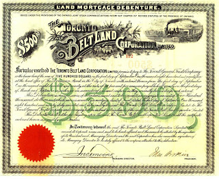
Toronto Belt Land Corporation Land Mortgage Debenture
The Highlands of Toronto was a prospectus -- essentially, a real estate sales brochure -- published in 1891 by the aforementioned Toronto Belt Land Corporation, extolling the benefits of the Belt Line and the picturesque nature of the bucolic suburbs it made accessible. John T. Moore, president of the Institute of Chartered Accountants, was the managing director of the Corporation (Moore Park is named after him).

The following bird’s eye view map of the Toronto Belt Line Railway appears at the end of the prospectus.

Click the image to view a full-size version.

1891 Birds eye view of Toronto Belt Line Railway route from the Highlands of Toronto prospectus

Other elements leading to the failure of the business were the fare (25 cents, quite high at the time) and the competing Toronto Street Railway, which carried considerable traffic as it was faster, providing more direct routes to downtown.

Bottom left: the Yonge St. Belt Line crossing
“... the Toronto Belt Line Railway makes its advent. Its mission is to economize time by rapid transit, and to carry men, women and children with comfort, safety and speed beyond the cramped and crowded city to the airy uplands; whence, having enjoyed the rest and refreshment of commodious homes and spacious grounds, they can return on the morrow to renew, with quickened energies, the task of life. It will also disclose some of the beauties which nature has lavished around Toronto which too long have remained unknown...”
- The Highlands of Toronto

A modern view for comparison
(via Google maps)

Going back to the first map, note the sections highlighted in red: Spring Valley (Moore Park), Forest Hill, Fairbank, Fairbank Junction. The developer would have been attempting to sell plots of land in those sections.

This map illustrates the lots available in Fairbank:

Click the image to view a full-size version.

Highlands of Toronto map showing Fairbank lots for sale

Highlands of Toronto plan of building lots for sale the property of the Toronto Belt Land Corporation in that portion designated "Fairbank" on the Belt Line Railway. Published by Alexander & Cable, 1910.
Map courtesy Toronto Public Library: T[1910]/4Msm

Bonus Map showing the ‘Northern Suburbs of Toronto’ in 1890. The Belt Line is marked in red:

Click the image to view a full-size version.

1890 Belt Line Map Showing Northern Suburbs of Toronto, compiled by Unwin, Foster Proudfoot

Belt line map shewing northern suburbs of Toronto. Compiled by Unwin, Foster & Proudfoot, published by Alexander & Cable, 1890.
Map courtesy Toronto Public Library: T1890-2/4Mlrg c1

Portions of the belt line were re-used for freight operations: the Yonge Loop delivered Canada’s first subway cars to Davisville Station in 1954 and also supplied Dominion Coal on Merton Avenue up until 1969.  

See Also
Please ‘Like’ and Share these maps with other Toronto history enthusiasts! (+1s are also welcome!)

1892 Toronto Railway Company's Map Showing Street Railway Lines

“This bird’s-eye view illustrates streetcar service provided by the Toronto Railway Company shortly after it took over operations in 1891. In spite of continued city growth, the company refused to extend its single-fares, build new lines or buy additional cars to service the area beyond the city limits of 1891. This inflexibility eventually led to the establishment of the publicly-owned Toronto Transportation Commission in 1921.”


There is a surprising amount of detail in this bird’s eye view -- at least for a transit map. Observe how the Don River has been straightened, while Garrison Creek has been buried. Route descriptions appear along the bottom. The depiction of smokestacks was artistically at the time a positive indicator of industrial progress.


Click the image to view a full-size version.

1892 Toronto Railway Company’s Map Showing Street Railway Lines

Toronto Railway Company’s Map Showing Street Railway Lines, 1892. Lithograph.
Image courtesy Toronto Public Librar: TRL, 970-16

“The Toronto Railway Company (TRC) was the first operator of horseless streetcars in Toronto.

Formed by a partnership between James Ross and William Mackenzie, a 30-year franchise was granted in 1891 to modernize transit operations after a previous 30 year franchise that saw horse car service from the Toronto Street Railways (TSR). At the end of the TSR franchise, the city ran the railway for eight months, but ended up granting another 30-year franchise to a private operator, the TRC. The first electric car ran on August 15, 1892, and the last horse car ran on August 31, 1894, to meet franchise requirements. There came to be problems with interpretation of the franchise terms, for the city. By 1912, the city limits had extended significantly, with the annexation of communities to the North, East and the West. 

After many attempts to force the TRC to serve these areas, the city created its own street railway operation -- the Toronto Civic Railways -- to do so, and built several routes. Repeated court battles did force the TRC to build new cars, but they were of old design. When the TRC franchise ended in 1921, the Toronto Transportation Commission [TTC] was created, combining with the city-operated Toronto Civic Railways lines.”

Toronto Railway Company (Wikipedia)


Bonus Map
The following map was published as part of a guidebook to Toronto, intended for visitors from the United States.

Click the image to view a full-size version.


Plan of the City of Toronto Showing Streetcar Lines, Canada Railway News Company, 1912.

Image via Illustrated Guide to Toronto by way of Niagara Falls (at end of book).

See Also
1892 Map of Toronto & Suburbs Shewing the Location of the Toronto Belt Line Railway

Bird’s Eye views
1870 Canadian Railway News Bird’s Eye View of Toronto
1876 PA Gross Bird’s Eye View of Toronto
1876 Gascard City of Toronto Bird’s Eye View from the Northern Railway elevator
1886 Wesbroom: City of Toronto [Bird’s Eye View]
1893 Barclay, Clark & Co. Bird’s Eye View Chromolithograph

Further reading
A Brief History of Transit in Toronto (start from section, ‘The First Stab at Public Ownership’

Please ‘Like’ and Share these maps with other Toronto history enthusiasts! (+1s are also welcome!)

Thursday, January 24, 2013

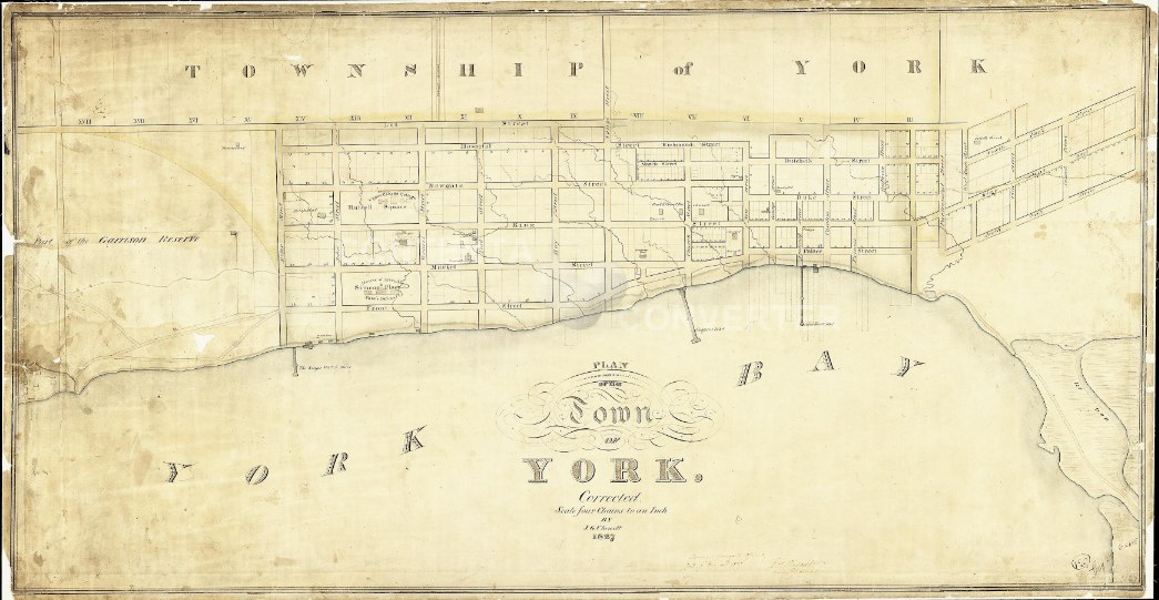
1827 Chewett Plan of the Town of York

James Grant Chewett (1793-1862) was the son of William Chewett, an important early surveyor. James Chewett became a deputy surveyor in 1819, and was mainly employed in the Surveyor-General's office, serving as Deputy Surveyor-General from 1832 to 1841. He prepared several plans of Toronto and an important map of Upper Canada for the Canada Company in 1826. He retired from government service in 1841 and later became president of the Bank of Toronto.’

- Isobel Ganton & Joan Winearls, MAPPING TORONTO'S FIRST CENTURY 1787-1884

Only major buildings are shown in this stark map. The Bank of Upper Canada opened at the corner of Duke and George (a building which still stands). Some of the structures indicated were yet to be built; for example Upper Canada College (1830) is shown in Russell Square; Osgoode Hall is shown but not named. In less than a decade, York would become Toronto...

‘Plan of the Town of York’, Corrected by J[ames] G[rant] Chewett, 1827.
Thomas Ridout (Surveyor General) has a signature on this map (faded, bottom mid-right).
Scale: Four chains to an inch.

Click the image to view a full-size version.

1827 Chewett Plan of the Town of York

Plan of the Town of York. Corrected. By J. G. Chewett. 1827.
[Sgd] Surveyor Generals Office York 7th Decemr 1827 Thos Ridout Surveyr General
Image courtesy Library and Archives Canada: NMC 16819. Winearls, MUC no. 2054

See Also
1834 Chewett Plan of the City of Toronto and Liberties

Please ‘Like’ and Share these maps with other Toronto history enthusiasts! (+1s are also welcome!)

Friday, January 18, 2013

1797 Smith Plan for the enlargement of York

“Surveys in 1796 and 1797 extended the town north to Lot (Queen) Street, west to York Street, and then west again to Peter Street. The blocks and lots of the New Town were much larger than those of the original town. An important focus for municipal activities was provided by setting aside blocks between the Old and New towns for public buildings. The St. Lawrence Market and St. James Cathedral still occupy the sites allotted to market and church.

In an attempt to prevent speculation, each person was allowed only one lot in the New Town. Note, however, that members of one family often held adjoining lots - a legal method of acquiring a large block of land for later resale.”

- Isobel Ganton & Joan Winearls, MAPPING TORONTO'S FIRST CENTURY 1787-1884

“Lt.-Gov. John Graves Simcoe left Upper Canada on July 21, 1796. Peter Russell, Receiver and Auditor General of Upper Canada, was chosen as Administrator of the province until Simcoe's return. In mid-1797 Russell — realizing the town needed more space for public buildings and settlement — extended the town north to Lot Street (now Queen Street) and west to York Street.”

- Wendy Smith, Peter Russell’s Expanded Town of York in The TORONTO PARK LOT PROJECT — an exploration of the earliest days of the TOWN OF YORK, founded in 1793 by John Graves Simcoe, first Lieutenant-Governor of Upper Canada. 

Click the images to view full-size versions.

1797 map showing the planned enlargement of York, by DW Smith

Plan submitted by Order of His Honor The President for the enlargement of York. The Blocks washed red are already surveyed - the unsurveyed part is projected in acre lots with a few exceptions. 

[ Signature ]: D.W. Smith A.S.G. [ On verso ]: His Honor the President Mr. Russell 9 June 1797 Plan of York as amended by Him.

Image courtesy Toronto Public Library: Ms1889.1.2
Winearls, MUC no. 2018

The next map from David Smith shows the assignment of the lots:

1797 Plan for the enlargement of York, DW Smith, map

Plan for the enlargement of York, as amended by Order of His Honor the President projected in Lots containing an acre more or less.

Signed: D.W. Smith A.S.G. 10 June 1797: In council at York, June 10th, 1797, Peter Russell [ Endorsed title on verso ]: His Honor the Prest 10th June 1797 approval of the Town plot of York - addition

Image courtesy Toronto Public Library: Ms1889.1.3
Winearls, MUC no. 2018 (2)

“By the end of that year, Russell had been persuaded by Chief Justice John Elmsley to extend the town boundary further west, to the limits of Fort York's 1,000-yard firing range — the "ordnance boundary" marked by the curved line in the map below. Russell named the street which set the western boundary Peter Street, after himself.”

- Wendy Smith, ibid.


His Honor the Presdt approval of the Town Plot of York. 2nd addition. Signed: Approved, Peter Russell. Copy W.C.

Image courtesy Toronto Public Library: Ms1889.1.4
Winearls, MUC no. 2018 (3)

“This copy of this plan was drawn by William Chewett [father of James Grant Chewett -N.] and signed "Approved Peter Russell" in 1797 or 1798.

Letter from Russell to Simcoe (in England), dated December 9, 1797:
... I have extended this town westward towards the Garrison and to the North as far as the base of (the) Hundred acre (Park Lots), reserving between the part that was laid out by your Excellency and this addition, a large space for public buildings (viz. a church, Court House, jail, market, hospital, schoolhouse, &c.), most of the lots have been already taken up and about forty houses erected and several more are beginning.” 
- Wendy Smith, ibid.

Sir David William Smith (1764-1837) was born in England. He began his career in the military but soon moved into the civil service and became a prominent member of the establishment in Upper Canada. He was a member of the first parliament of Upper Canada and was elected Speaker in 1797. In 1792 he was appointed Surveyor-General of Upper Canada, a post he held until he returned to England in 1804. He was made a baronet in 1821.” - Ganton/Winearls, ibid.

TORONTO PARK LOT PROJECT (Wendy Smith) text used under Creative Commons Attribution-NonCommercial-ShareAlike 2.5 Canada Licence.
Please ‘Like’ and Share these maps with other Toronto history enthusiasts! (+1s are also welcome!)

Wednesday, January 16, 2013

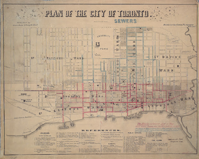
1858 Unwin Plan of the City of Toronto: Sewers

Toronto’s sewage system has a rich and complicated history.

‘The 1840s and 1850s saw a recognizably modern city begin to take shape. This was due partly to population growth, but also to the innovations of the Victorian era, such as the installation of [gravity-fed] sewers and the other mundane elements that made urban life congenial.’

This plan ‘shows Toronto from Dovercourt to the Don River and Bloor St. south to the lakefront. Churches, banks and public offices are referenced, as well as the fire alarms for the wards. Manuscript annotations indicate where sewers have been laid up to 1875 and note the depths of sewers at certain points. Approximate scale noted in manuscript.’ - TPL

Click the image to view a full-size version.

1858 Toronto Proposed Sewers

Plan of the City of Toronto - SEWERS
Published by James Bain 37 King St. East / Drawn by Chas Unwin P.L. Surveyor York Chambs. / Maclear & Co. Liths Toronto. 1835
Image courtesy Toronto Public Library: Ms1921.9. Winearls, MUC no. 2135

As noted, the above map is from 1858, but has subsequent annotations overlaid onto it with respect to the sewers up to 1875. View the original map (3MB) without the annotations (A different copy in obviously poorer condition).

Garrison Creek and the Interceptor Sewer System
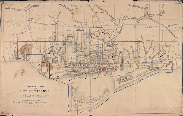
Of contextual note in the following related map: the covering of Garrison Creek, one of the city’s first major sewerage infrastructure projects.

“By the 1880s, as the city expanded westward, the pollution of the creek became an increasingly pressing issue in municipal elections. In 1881, the city had the Garrison Creek straightened between Queen Street and the Western Stockyards (north of Fort York), probably with the aim of increasing the flow and alleviated the concerns already being expressed about the fouling of the creek.  Whatever the aim (and the straightening might equally have been designed to rationalize and improve the properties along the waterway), the exercise failed to stem the calls for stronger action.

While it took years to mobilize support and capital for a permanent solution to an increasingly polluted creek, by 1884 all the key pieces were in place. [...] At the time, the creek was seen to be having a significant effect on property values in the area, and along with them on the taxes the city could assess, both of which would improve with the construction of a sewer. The city had significant property holdings of its own along both sides of the creek which would also be enriched by its removal. Indeed, the sewering of the Garrison Creek was an important factor in provoking the 1887-1890 real estate boom.”

- Michael Cook, Burying the Garrison Creek: A History [worth reading in full!]

Click the image to view a full-size version.

1888 Toronto Plan of Proposed Interceptor Sewers and Sewers already constructed

Map of the City of Toronto Shewing Proposed Interceptor Sewers and Sewers Already Constructed, 1888
Image courtesy Toronto Public Library: T1888-2/4Mlrg

“By 1886 the City Engineer was seeking $1.4 million for construction of a system of intercepting sewers [see red horizontal lines -N.] largely equivalent to what was ultimately constructed more than twenty years later. But each time the city proposed the expenditure to Toronto's citizens, the measure was voted down by the electorate.” - Cook, ibid.

Note how the interceptors go out to the east end, out to Woodbine...

The next map contains a wealth of interesting detail about the city. It shows the proposed 'High' and 'Low' intercepting lines in greater clarity, in red with arrows to indicate the flow direction out to an outflow into Lake Ontario south of Victoria Park Avenue. The blue lines are the main sewers at the time. Note the pumping station at Queen and Pape, and at John Street by the waterfront.

Click the image to view a full-size version (5mb):

1889 Toronto Plan of proposed Intercepting Sewers and Outfall by Hering & Gray

1889 Plan of the City of Toronto, Proposed Intercepting Sewers and Outfall
Hering, Rudolph G. & Gray, Samuel M., Consulting Engineers, February 1889
City Engineers Office Toronto, March 6, 1889
Printed by Copp Clark Co. Ltd.

Image courtesy City of Toronto Archives: Fonds 200, Series 725, File 13 - MT98 (CRC172)
U of T Map and Data Library has a somewhat tattered version: G3524 .T61 N46 1889

A 1903 Plan:

April, 1901 Plan of the City of Toronto - sewage disposal crude delivery estimate no. 1B
City Engineer’s Office
Image courtesy U of T Map and Data Library: G3524 T61N46 20 1889-1901

See also: 1878 Copps Clark & Co. Plan of the City of Toronto: Waterworks


Further reading (there’s a lot of great history... buried... here!)

Please ‘Like’ and Share these maps with other Toronto history enthusiasts! (+1s are also welcome!)

Tuesday, January 15, 2013

1788 Mann “Plan of Torento Harbour with the proposed Town and part of the Settlement”

“This earliest detailed proposal for the town the British planned to build near the natural harbour was never laid out as it was too large and elaborate for a pioneer community. It was also applied to the site with little regard for its natural features.

This plan is similar to the model plan, authorized by Governor Lord Dorchester the following year, for townsites in townships fronting on water. The mile square town was surrounded by a government and military reserve on the waterfront and by a public common. Beyond this were 24-acre "town parks" for the private use of some residents of the town.”

- Isobel Ganton & Joan Winearls, MAPPING TORONTO'S FIRST CENTURY 1787-1884

Click the image to view a full-size version (pdf).

Plan of Torento Harbour with the proposed Town and part of the Settlement, Gother Mann

Plan of Torento Harbour with the proposed Town and part of the Settlement
Signed 6th Dec. 1788, Gother Mann Captain of Command, Royal Engineers
Scale: One mile to two inches

Image courtesy Library and Archives Canada: NMC4434/5(4433?). (U of T has this scan.)
Winearls, MUC no. 2011 (2)

Ruins of a trading fort = the french Fort Rouillé, burned in 1759.

“... This 1788 plan provides the perfect graphic representation of the British Government’s attempt to impose eighteenth-century rational order on the Canadian wilderness. It is a view of Toronto as a tabula rasa, a canvas on which to project grand plans and and hoped-for futures.”
“As can be seen in the illustration, the plan includes a central square containing military and government buildings surrounded by a common, which, in turn, is enclosed to the north, east and west by a residential area. The whole territory is bounded by the modern High Park, Broadview Avenue, and Bloor Street. The old Carrying Place [cf. the Toronto Purchase map -N.] is there, but shown as a road leading to Lake la Clie, a misspelling of lac aux Claies, the name usually given to Lake Simcoe as the former ‘lac Toronto’ fell into disuse.

The plan is what one might expect of a military engineer and may go back in origin to the gridiron settlements that Roman engineers designed for coloni, or pensioned veterans in garrison towns. In Roman terms, Mann’s square of public buildings becomes a forum and the residential squares a setting for the houses of the discharged soldiers [...] The idea of public buildings in a neat British square separated in perpetuity from the residential area by a green common with shade trees and sheep quietly grazing is quite delightful, but fantastic and unrealistic when one considers the rising terrain and the deeply penetrating ravines. These topographical problems would hardly be appreciated in London, where Mann’s plan of ‘Torento’ was forwarded with the colonial correspondence in 1790.”

- Eric Ross Arthur & Stephen A. Otto, Toronto: No Mean City

Gother Mann (1747-1830), a graduate of the Royal Military Academy, commanded the Royal Engineers in Canada from 1785 to 1791 and from 1794 to 1804. Returning to England, he later commanded the whole Corps of Engineers, and ended his career as a general and Inspector General of Fortifications.”  - Ganton/Winearls, ibid.

John Collins, the Deputy Surveyor General -- also present the previous year at the Toronto Purchase -- was responsible for this similar map, dated the same year:

Click the image to view a full-size version.

1788 Plan of Harbour of Toronto, John Collins

Plan of the Harbour of Toronto with the proposed town and settlement.
‘Copied from a plan of Mr. Collins, it does not agree with the survey made by L. Kotte in 1783 (Plan 1.24) Engr. D. R. Kotte's survey agrees with one taken in 1793 by J. Bouchette Chateau. In Lord Dorchester's No. 48 to major Genl. Simcoe.’

‘Explanation : The lots round the common are called town parks. The lots beyond are farm lots A.A.A. reserved lots for public purposes. A on map refers to situation in Capt. Mann's report of the 6th December 1788, as appearing proper to be occupied for the defence of the entrance of the harbour.’

The top of the map corresponds roughly to where Finch Avenue now runs. The map was used to demonstrate land that should be held in reserve where such reserves may probably be required for Public purposes.

Image courtesy TPL: T1788/4Mlrg. See also LAC.
Winearls, MUC no. 2010

Please ‘Like’ and Share these maps with other Toronto history enthusiasts! (+1s are also welcome!)

Saturday, January 12, 2013

1893 Barclay, Clark & Co. Bird’s Eye View Chromolithograph

What a splendid bird’s eye view map! It’s replete with so many intricate historical details to pore over again and again.

There are some discrepancies. For example, there’s the presence of the then-new (now old) City Hall, which was only completed in 1899 (it was under construction for over a decade). It was common practice in drawings like this to include structures not yet constructed, as well as prospective buildings -- an appeal to civic pride.

“... The bird’s-eye map is an artist’s relatively subjective view of the city. Indeed, artists were commissioned to draw bird’s-eye views, which were partly intended to promote the image of the town depicted. Artistic licence was usually employed to emphasise [sic] what were considered at the time to be the more desirable urban attributes–grand buildings, thriving industry and bustling commercial areas and transportation facilities. The reliability of the information on the bird’s-eye map, an artist’s subjective interpretation of the townscape, should be cross-checked, where possible.”

- Bird’s-Eye Views of Canadian Cities: A Review, M.F. Fox [Urban History Review (No.1-77)] [via Kevin Plummer]

Click the image to view a full-size version.


Bird's-eye view, looking n. from harbour to n. of Bloor St. and some points beyond, from Humber R. on the west to Victoria Park Ave. on the east. Published by: Barclay, Clark & Co. Lithographers

Inscription: “Entered according to Act of Parliament of Canada, in the year 1893 by Barclay, Clark & Co. in the Office of the Minister of Agriculture.”

Image Courtesy Toronto Public Library: 916-2-1 to 3 Cab III

“The bird's-eye view is an oblique perspective drawing of a city viewed from an elevation of several thousand feet above it. The views include a three-dimensional portrayal of buildings and other features in an attempt to combine the main topographical aspects of a map with the details possible in a picture. The views appealed to civic pride and were also seen as an encouragement to commercial growth. Sold at $3 to $10, they became popular wall hangings during the last third of the 19th century. Views were usually done by artists who solicited subscriptions in advance to guarantee sales, and who actually went around the city sketching buildings.”

- Isobel Ganton & Joan Winearls, MAPPING TORONTO'S FIRST CENTURY 1787-1884

Drop me a line if you know anything more about the context for this map and the circumstances which led to its printing!

1813 Williams Sketch of the ground in advance of and including York Upper Canada

“The War of 1812 resulted in the mapping of York in a different way. In this reconnaissance map, the military noted the natural features of the area instead of the survey lines and recorded actual buildings and streets rather than lot lines and road allowances.

Evidence of war is visible in the notation "frigate burnt" (central shoreline), a reference to the Sir Isaac Brock which was burnt to prevent its capture by the Americans. The disappearance of the centre part of the Parliament Buildings (southeast of the Old Town) was also a legacy of the war - it was burnt by the Americans when they captured York in 1813. [It has been pointed out to me that this is in error; the centre part did not exist then; only the wings were built in 1797. -N.] Most of the scattered and poorly protected buildings of the garrison were also destroyed.”

- Isobel Ganton & Joan Winearls, MAPPING TORONTO'S FIRST CENTURY 1787-1884

Click the image to view a full-size version (4MB).

Map: 1813 Williams Sketch of the ground in advance of and including York Upper Canada

Sketch of the ground in advance of and including York Upper Canada, by Geo. Williams, 1813.
Image courtesy Library and Archives Canada: NMC 22819.
Winearls, MUC no. 2035

Related is the following 1814 map by the same surveyor, George Williams: “Plan of the town and harbour of York”

This map, also completed after the War of 1812, shows outlines of the major buildings of the town of York, and highlights the location of various military structures through the town -- including the number of men. Scale: 10 chains to an inch.

Interesting points of note:
  • the Blockhouse at Gibraltar point opposite Fort York
  • the guardhouse on the spit - guarding versus a portage
  • the 'flanking batteries to tete du pont' (!) (by Don River)
It features the same note (bottom left) as the above plan: "Accompanying Lt. Col. Hughes letter to Lt. General Mann, dated 16 August 1814." With both of these maps in hand, the Lt. General could refresh his understanding of the strategic and tactical environment at York with a glance. [Note: This would be Gother Mann, earlier responsible for the 1788 “Plan of Torento Harbour”.]

Click the image to view a full-size version (PDF).


Plan of the Town and Harbour of York, by George Williams, 1814.
Image courtesy Library and Archives Canada: NMC 21771. Winearls, MUC no. 2037

Meanwhile, the Toronto Public Library has this copy, which appears to be of more recent vintage (click to view full size):

1814  Plan of the town and harbour of York (Toronto), George Williams


Plan of the Town and Harbour of York, by George Williams, 1814.
Image courtesy of Toronto Public Library: T1814/4Mlrg


‘George Williams was a member of the semi-civilian corps of Royal Military Surveyors and Draughtsmen, a unit set up exclusively for the purpose of making maps and instructing cadets of the Royal Engineers in map-making.’ - Ganton/Winearls, ibid.

Gratuitous bonus: Arrival of the American Fleet (click to view large version):

Bird's-eye view looking northeast from approximately foot of Parkside Drive, showing arrival of American fleet
prior to capture of York, 27 April 1813. (Painting by Owen Staples circa 1914). Courtesy TPL
Key to this image [The numerals are visible in the large version]

A simplified overview of the action:
Map of York. From The Pictorial Field-Book of the War of 1812 by Benson Lossing [1869].
Map courtesy Archives of Ontario. Reference Code: 971 .034 LOS, page 590

Please ‘Like’ and Share these maps with other Toronto history enthusiasts! (+1s are also welcome!)

1816 Nicolls & Duberger Plan of the Fort at York Upper Canada

“After the War of 1812, Fort York was rebuilt to provide quarters for 950 men within a defensive wall. Today’s Old Fort York reconstructs the fort of this period.

Note the defensive position of the fort, which was located on a bluff above the lakeshore and protected by Garrison Creek ravine. Later fill has extended the shore and changed the surrounding topography.

The crater at the lakeshore caused by the explosion of the powder magazine in 1813 is marked by 'D'. ”

- Isobel Ganton & Joan Winearls, MAPPING TORONTO'S FIRST CENTURY 1787-1884

With respect to the crater -- see the south side of the rampart. Read a detailed history of the crater here.

Click the image to view a full-size version.


Plan of the Fort at York Upper Canada shewing its state in March 1816. Drafted by: Royl. Engineers Drwg. Room, Quebec, 16th Feby. 1816, J[ean]. B[aptiste]. Duberger, Junr. Quebec, 24th June 1816, G[ustavus]. Nicolls, Lt. Col. Rl. Engineers.

Image courtesy Library and Archives Canada: NMC 22819. Winearls, MUC no. 2035
[The University of Toronto Map and Data Library has a black and white scan of this map (NMC23139), while the Toronto Public Library features a redrawn version (T1816-2/4Mlrg).]

The name of the surveyor/draughtsman, J.B. Duberger, and the date and place of the drawing can just barely be discerned, bottom right.

Nicolls and Duberger also created this accompanying, same-dated Plan of the harbour, fort and town of York, the capital of Upper Canada, March 16th 1816:

Click the image to view a full-size version.


Image courtesy Toronto Public Library: T1816/4Mlrg [See also: LAC NMC 17441]
Winearls, MUC no. 2037

‘Signed Quebec 24th June 1816, G. Nicolls Lt. Coln. Engineers and Quebec. J. B. Duberger Jun'r. Shows buildings, harbour depths and descriptions of harbour bottom. Includes reference that The Battery had all guns and were made use of on the 27th of April, except the one at the marsh. Government buildings and blockhouse were burnt by Americans as were many others.’

Scale: 10 chains to an inch.

Gustavus Nicolls’ distinctive signature also appears on the 1833 Bonnycastle No.1 Plan of the Town and Harbour of York Upper Canada.

A few years later, Elias W. Durnford produced the following plan of the fort. It indicates the construction materials used for specific buildings.

Click the image to view a full-size version.


Plan of the fort at York, no. 24. E.W. Durnford, Sept 24, 1823.
Image courtesy Toronto Public Library: T1823/4Msm.

Durnford’s Fort plan, much like Nicolls’, was accompanied by a larger scale plan showing the relationship of the Fort to the Town:

Click the image to view a full-size version.


Plan of York, no. 24, See General Plan of the Canadies (y) E.W. Durnford, Sept 24, 1823
Image courtesy Toronto Public Library: T1823-2/4Msm

Unfortunately the key does not seem to be available...

See also
Want to learn more about the crater and the Battle of Fort York? Watch Explosion 1812 (via the History Channel).

Also, a wide swathe of maps relating to Fort York and the surrounding Military Reserve may be found at the Fort York and Garrison Common Maps project.

Please ‘Like’ and Share these maps with other Toronto history enthusiasts! (+1s are also welcome!)

Blog Archive