Friday, October 11, 2013

1837 Hawkins: Toronto Military Reserve [Feb. 1837]

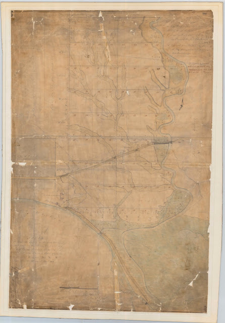
Starting in 1833, Sir John Colborne oversaw a major expansion westward of the city, with the sale of over 200 acres of the Military Reserve adjoining Fort York east of Garrison Creek, in order to fund the construction of a new fort. The following, final official plan for the area documents the result of that process, and is packed with the names of lot owners and corresponding lot numbers.

Click the image to view a full-size version (PDF). 


Toronto Military Reserve. Resurvey by Wm Hawkins Dy. Surveyor. By order of His Excellency Sir Francis B. Head Lieut. Governor U. Canada &c &c &c as laid out in Town Lots on the east of the Ravine. [Sgd] To the Honble John Macaulay Surveyor General &c &c &c Toronto William Hawkins Dy Surveyor Toronto 18th Feby 1837 [Certified and sgd] R.H. Bonnycastle Captn Royal Engineers Western District U.C. 21st Feby 1837

Source: Ontario Ministry of Natural Resources, Office of the Surveyor General: 348-H24
© 2013 Queens Printer Ontario
Winearls, MUC no. 2064 (15)

See the 1797 Smith Plan for the enlargement of York for the previous major town expansion.

Please ‘Like’ and Share these maps with other Toronto history enthusiasts! (+1s are also welcome!)

Explore Toronto's past through maps...

Featuring simple and free access to a broad selection of notable historical maps of Toronto, this site aims to generate curiosity, and to serve as an easy entry point for discovery and further investigation.

1818 Lieut. G. Phillpotts: Plan of York
How did ‘Muddy York’ develop into the modern metropolis we live in?

These important maps from our past reveal the essential tension of this city — between the quest for growth, and the heavy influence of what came before. They reflect a municipality in constant flux, and give insight into our contemporary urban identity.

And besides, who doesn’t love poring over old maps of Toronto?

- Nathan Ng, April 2013.

Start your exploration—complete list of maps
More about this project...

Monday, October 7, 2013

1852 Liddy: [I]ncorporated Village of Yorkville in the County of York and Province of Canada

“The generous limits of Yorkville at incorporation show that the boom mentality prevailed even in a village so small that its urban landowners could all be listed on the sides of the map. Different patterns of transitional subdivision are evident along Yonge Street and Avenue Road to the west; these patterns had already begun to determine the location of urban streets.

The map, although somewhat resembling folk-art in the representation of the trees and the brickyard, shows the influence of the British Ordnance Survey in the patterning of fields. Note the early idea for a rectangular plan in part of the Rosedale estate (right centre), soon to be superseded by a dramatically different plan.”

- Isobel Ganton & Joan Winearls, MAPPING TORONTO'S FIRST CENTURY 1787-1884

Click the image to view a full-size version (PDF, 3MB). 


[I]ncorporated Village of Yorkville in the County of York and Province of Canada. 
Drawn from an actual Survey by G.P. Liddy Late of the Engineering Department of the Ordnance Survey of Great Britain and Ireland. Provincial Land Surveyor, Civil Engineer etc. [Sgd] Geo. P. L[iddy]

Source: Ontario Ministry of Natural Resources, Office of the Surveyor General: SR7017
Copyright:  2013 Queens Printer Ontario
Winearls, MUC no. 2091

Yorkville was incorporated January 1, 1853.


Please ‘Like’ and Share these maps with other Toronto history enthusiasts! (+1s are also welcome!)

Thursday, September 5, 2013

1868 Gehle, Fawkes & Hassard: Reconnaissance Sketches of Toronto Area

‘These reconnaissance maps were made to help the military to meet the threat of raids by the American-based Fenians on Toronto, now the capital of the new Province of Ontario. The military nature of the maps is evident (see "References") in the type of information recorded: roads passable for artillery, farms able to supply horses and to accommodate soldiers, and sources of fresh water.

These maps are the first to show the topography of the region in detail. They reveal the close relationship between river valleys and uncleared land. The routing of roads around physical barriers is clear as well.

Although most major buildings are shown, only those important to the military, such as the taverns and hotels along the roads out of town, are identified. A few industrial sites, such as the brickyards along Kingston Road and in Yorkville, are also noted.

Two Royal Engineers produced this set of maps. The difference in their styles is evident...’

- Isobel Ganton & Joan Winearls, MAPPING TORONTO'S FIRST CENTURY 1787-1884

Click the images to view full-size versions (PDF). 


Sketch Sheets of a Winter Reconnaissance of the Country W. of Toronto to the Humber River, and North to the Davenport Road
[Surveyed by:] H.J.W. [Henry John Wolsteyn] Gehle, Lt. R.E. 11/1/68
[Signed] F.C. [Fairfax Charles] Hassard, Lt. Col. 15/1/68

Image courtesy of Library and Archives Canada: NMC20712

Note in the above map the Sandy beach, good landing for boats (Americans landed here in 1812).


Sketch Sheet of a Reconnaissance of Ground in the neighbourhood of Toronto lying in the 2nd and 3rd Concessions from the Bay, east and west of Yonge Street. December Quarter 1868

[Surveyor:] F.H. Fawkes, Lt. R.E. 22.1.69
[Signature] F.C. Hassard, Col. R.E. 26.1.69

Image courtesy of Library and Archives Canada: NMC20710


Sketch Sheets of a Winter Reconnaissance of the Country East of Toronto, between the Don River; & the Township of Scarboro, on the E. & the Don & Danforth Road. on the N. to the Lake Shore. Office Copy - original to Montreal, 20 Apl. 68. 
[Surveyor:] H.J.W. Gehle, Lt. R.E. 17/Apl. 68.

Image courtesy of Library and Archives Canada: NMC20711


Sketch of a Reconnaissance of ground in the neighbourhood of Toronto being the Eastern extremity of the 2nd and 3rd Concessions from the Bay  [This map is essentially the eastern continuation of NMC20710 above. -N.]

Surveyed by: F.H. Fawkes, Lt. R.E., June Quarter 1869.
F.C. Hassard, Lt. Col. R.E. 20 August, 1869.

Image courtesy of Library and Archives Canada: NMC22847 [via Derek Hayes’ Historical Atlas of Toronto]

Research Note: There is one additional map in this set I have not [yet] been able to procure: Sketch sheet of a Reconnaissance of Ground in the Neigbourhood of Toronto Lying principally in the Third Concession from the Bay and Extending from Humber Eastward (NMC22845)

Bonus: Etobicoke


Toronto District Sketch Sheets of a Reconnaissance of the Country between the rivers Humber and Etobicoke from the shore of Lake Ontario to Dundas Street on the North.  1867. [Sgd] H.J.W. Gehle, Lt. R.E., 16/7/67

Note: Unfortunately the only high-resolution scan available is in black and white.
Color Thumbnail courtesy Library and Archives Canada: NMC26685
B&W expanded Scan courtesy University of Toronto Map and Data Library: NMC26685


Sketch Sheets of a Reconnaissance in the County of York, Township of Etobicoke, between the Humber & Etobicoke Rivers, N. of Dundas Street 
[Sgd] H.J.W. Gehle, Lt. R.E. 16/10/67.

Image courtesy University of Toronto Map and Data Library: NMC26681. [LAC record: NMC26681]

Please ‘Like’ and Share these maps with other Toronto history enthusiasts! (+1s are also welcome!)

Saturday, August 17, 2013

1859 University of Toronto Campus / Queen’s Park [Plan of the University Park]

The University of Toronto / King’s College / University College
‘The university land had been little developed since its purchase in 1829 [by Bishop Strachan]. King’s College ['The Asylum', lower right] had been built in 1842, but was later used as a lunatic asylum. In 1854 the eastern part of the site (now Queen’s Park) was proposed as the location for new provincial parliament buildings [but nothing was built until 1886; see 2nd map below. -N.].

University College was opened in 1859 and some of the curving drives were added in that year. Taddle Creek, prominently shown in the middle, was polluted with sewage from Yorkville by the 1870s and remained a bone of contention between city and university until it was covered over in the 1880s.’

- Isobel Ganton & Joan Winearls, MAPPING TORONTO'S FIRST CENTURY 1787-1884

Click the image to view a full-size version. 


Campus Map of area bounded by College, St. George, Bloor and Surrey Place [Plan of the University Park], c. 1859
Map courtesy of: University of Toronto Archives, 2003-42-3f [A1965-0001(20)]
Winearls, MUC no. 2103 (2)

Queen’s Park
In 1854 the eastern portion of the university lands was the proposed location for the new legislature buildings, as reflected in this earlier map by John Stoughton Dennis (see next) showing nearby lots for sale from the Denison estate. It was then hoped that Toronto would be chosen by Queen Victoria as the permanent capital of the Province of Canada. Due to a lack of funds (and Toronto being passed over in favour of Ottawa), the depicted plan by Cumberland and Ridout for the Parliament Buildings “about to be erected” was never built.

Click the image to view a full-size version. 


Plan of Part of the City of Toronto Shewing the Town Lots on Bellevue For Sale by the Trustees for the Denison Estate March 1854
John Stoughton Dennis P.L.S. Maclear & Co. Lith. Toronto
Map courtesy of Toronto Public Library: T1854/4Msm
Winearls, MUC no. 2105

In 1859 the University leased 49 acres—an area encompassing the present day Ontario Legislature, parts of the modern day university campus, and portions of College Street and University Avenue—to the City of Toronto for a period of 999 years, to create a public park. Queen’s Park was officially opened by the Prince of Wales on September 11, 1860.

It would take decades to revive the notion of erecting legislature buildings on the site [see next map]. In 1880, the southern portion of the Park was turned over to the Province of Ontario for construction. Observe how the former King's College building, used as the 'University Lunatic Asylum' until 1869, is now merely labelled 'Old Building to be Removed'.

Click the image to view a full-size version. 


Site of the proposed parliament buildings, Ontario. Queen's Park.
Department of Public Works, Ontario. Toronto, April 7, 1880
Map courtesy of Toronto Public Library: T1880/4Mlrg

Supplementary Photos — View from University College
I came across this set of four remarkable photos taken in 1859 by William Notman, from the top of University College. The views they depict correspond to a large section of the 1859 map of the campus.

Looking east from University College to King’s College/
the University Lunatic Asylum

Looking south east to the Moss Hall (the Medical Building).
The closer structure is the residence of George Kingston,
the Director of the Observatory.

Looking south to the Magnetic Observatory (in its original location)

Looking north towards Yorkville

Reference: see E 9-277 and E 9-278. Note: I only confirmed the provenance for these two photos, but am inclined to believe that the other two are also Notman’s. Please let me know if there is evidence to the contrary!

Bonus Map — 1852 Exhibition Grounds
The following map shows the Exhibition Grounds in 1852,  located that year a little south of Queen’s Park along the west side of College Avenue (a.k.a. University).


Sketch of the Exhibition Grounds, Toronto
Lithograph by S.A.F. in Canadian Journal v.1, no.3 (October 1852) facing p. 49.
Map courtesy of Toronto Public Library: JRR 3539

Further reading on Queen’s Park:
Queen’s Park - Via Ontario Heritage Trust.

Please ‘Like’ and Share these maps with other Toronto history enthusiasts! (+1s are also welcome!)

Sunday, June 23, 2013

1817 Smith: Plan of York, U.C. & 1818 Plan of the Town of York

This map was surveyed and drawn by Lieut. E.A. Smith of the 70th Infantry, and provided to Sir John Coape Sherbrooke, the Governor General of British North America at the time (via the Quartermaster General’s Office, Upper Canada).

Numerous key structures are noted, including the Garrison, Gibraltar Point Lighthouse, the Government House, and the ravine Blockhouse (roughly where Trinity Bellwoods Park is). As well, the estates of several leading citizens are indicated. The Smith map was part of a historically significant collection of Sherbrooke’s papers purchased at auction in June 2013 by Library and Archives Canada.

Click the image to view a full-size version. 


Plan of York, U.C. / Surveyed and Drawn August 1817, by Lieut. E.A. Smith, 70th Inf'y
Image courtesy of Library and Archives Canada
[Note: Winearls, MUC no. 2041 is a later, but smaller and less detailed version of this plan, prepared for Sherbrooke's successor, Lord Dalhousie. It is held by the William Inglis Morse Collection at Acadia University: 1931.004-WIM/58]

The next plan from the following year is provided as a supplement. It shows the names of lot owners for the town including park lots.

Click the image to view a full size version.


Plan of the Town of York W.C. [9 June 1818]
Image courtesy Toronto Public Library: T1816-3/4Mlrg. Winearls, MUC no. 2044

It’s worth taking the time to compare the above maps with the two Williams plans, and the 1818 Phillpotts Plan of York.


Please ‘Like’ and Share these maps with other Toronto history enthusiasts! (+1s are also welcome!)

Monday, March 25, 2013

1886 Wesbroom: City of Toronto [Bird’s Eye View]

“This bird’s eye view [...] shows more clearly than either maps or streetscape photographs the congestion of the downtown core and the unrelenting zeal with which the grid pattern of streets—first laid out for Simcoe in 1793—had been stretched across the landscape on either side of the arrow-straight line of Yonge. Standing out against this pattern are the few attempts to mitigate the worst aspects of the grid plan: natural changes like King Street / Kingston Road, which turns northeast on the right side of the view; the carefully planned avenues like Spadina (with its crescent at the north end) and University; and the park-like green spaces scattered throughout the city [...]

If proof were needed that the Victorians, just as much as the Georgians, were proud and capable city builders, this bird’s eye view provides it amply. A celebration of their creation, it is a lasting testimony of what had been created in Toronto.”

- William Dendy, Lost Toronto

Click the image to view a full-size version. 

City of Toronto [Bird’s Eye View], 1886, W. Wesbroom

City of Toronto
Lithograph by W. Wesbroom, 1886 (? see note below)
Toronto Lithographing Company

Image courtesy Toronto Public Library: CHPC accession number 975-29 Cab III. Another copy is held by the Thomas Fisher Rare Books Library at U of T: G3524 .T61 1886. The image above is a photograph I took in person; if and when the TPL digitizes the map I’ll use their scan.

The Toronto Lithographing Company seems to have done especially fine work, wouldn’t you say?
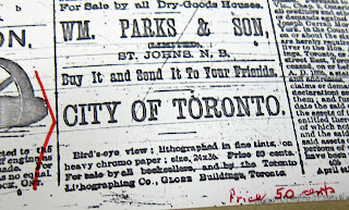
1886 Globe advertisement for Wesbroom Bird's Eye View of Toronto map
Advertisement: The Globe, May 22, 1886 

Note: Dendy’s Lost Toronto — which uses this bird’s eye view as its cover — gives an approximate date of 1878. Derek Hayes’ Historical Atlas of Toronto indicates 1884. These may be slightly different prints, or they may be the same and there just isn’t agreement on the actual date...

The Osborne Collection at the Toronto Public Library (Lillian H. Smith branch) features this cropped jigsaw puzzle of the map in their Canadiana holdings:

Wesbroom Bird's eye view of Toronto: jigsaw puzzle

Lovely.

See Also [Bird’s Eye Views]
1870 Canadian Railway News Bird’s Eye View of Toronto
1876 PA Gross Bird's Eye View of Toronto
1876 Gascard City of Toronto Bird’s Eye View from the Northern Railway elevator
1892 Toronto Railway Company Map Shewing Toronto Street Railway Lines
1893 Barclay, Clark & Co. Bird’s Eye View Chromolithograph

Please ‘Like’ and Share these maps with other Toronto history enthusiasts! (+1s are also welcome!)

Tuesday, March 5, 2013

1791 Jones: An accurate Plan of a Survey [...] of the River Trent (head) [North shore] of Lake Ontario to Toronto

“This important survey by Augustus Jones established the eastern sideline (now Victoria Park Avenue) and the baseline (now Queen Street) for Dublin (York) Township. The township lines formed the basic framework for all later development and thus determined the eventual northwest-southeast orientation of Toronto. The survey recorded here began 90 miles east of Toronto at the Bay of Quinte and laid out the fronts of 11 townships between there and York. Wherever possible, the baselines of townships were laid out parallel to the lake shore.”

- Isobel Ganton & Joan Winearls, MAPPING TORONTO'S FIRST CENTURY 1787-1884

Note that York township was briefly named Dublin (and Scarborough, Glasgow), prior to Simcoe’s arrival in 1793. It is likely Surveyor General Andrew Russell who wrote in the revised name in 1856.

Click the image to view a full-size version. 

An Accurate Plan of a Survey [from] the River Trent, North [Shore] of Lake Ontario to Toronto by Augustus Jones, 1791

An accurate Plan of a Survey [words missing] of the River Trent (Head) [words missing - North shore?] of Lake Ontario to Toronto [words missing] by Augustus Jones, 1791.
Source: Ontario Ministry of Natural Resources, Office of the Surveyor General, Plan Ref: SR5803 O6-4
Copyright:  2013 Queens Printer Ontario
Winearls, MUC no. 316

The above detail shows only the westerly York portion. View the entire map here (note: it’s quite long horizontally!).

The following, slightly more detailed survey of Dublin by Jones, was a copy made by John Frederick Holland. The horizontal 'front line' line is what later became Lot (then Queen) Street. ‘Toronto Fort’ indicates the location of Fort Rouillé.

I’m curious what that peninsula south of lot 23 is supposed to be.

Click the image to view a full-size version (PDF).

Plan of Eleven Townships fronting on Lake Ontario beginning at the River Trent and extending westerly to Toronto, Augustus Jones, 1791

Plan of Eleven Townships fronting on Lake Ontario beginning at the River Trent and extending westerly to Toronto as laid out and surveyed by Augustus Jones Dy PL Survr, A true copy by Jn Fk Holland [Sgd] Samuel Holland Surveyr Genl, 1791.

Image courtesy of Ontario Ministry of Natural Resources, Office of the Surveyor General, Plan Ref: 2391 K25
Winearls, MUC no. 316 (2)

Augustus Jones (circa 1763-1836) was a Loyalist. He was appointed a Deputy Surveyor in 1791 and was responsible for the survey of most of York Township, Yonge Street, part of Dundas Street, the new part of the town of York, and many townships east of Toronto and in the Hamilton area. He did little surveying after 1799, but retired to his land, marrying the daughter of a chief of the Mohawks.”
- Ganton/Winearls, ibid.

Please ‘Like’ and Share these maps with other Toronto history enthusiasts! (+1s are also welcome!)


Wednesday, February 20, 2013

1834 Bonnycastle/Tazewell: City of Toronto: The Capital of Upper Canada

Act to Incorporate the City of Toronto, March 6, 1834
Act to Incorporate Toronto
Courtesy TPL: 352.07135 T5916 BR
“The Town of York was incorporated as the City of Toronto on March 6, 1834, and this map was produced to record the event. It was the first separately published map of the city. The boundaries of the city and its liberties -- areas appended to the city to provide room for expansion -- are shown in the small inset map. The northern boundary of the city proper was 400 yards north of Queen Street [aka Lot Street -N.], an indication that the southern part of the park lots had been developed by the early 1830s.

Note the clusters of public buildings: those of municipal significance east of Yonge at the edge of the Old Town and the provincial buildings in the New Town. The "Lands Reserved for a Public Pleasure Ground" and a "Proposed Esplanade" on the waterfront indicate an early interest in keeping the area for recreational uses.”

- Isobel Ganton & Joan Winearls, MAPPING TORONTO'S FIRST CENTURY 1787-1884

City of Toronto: The Capital of Upper Canada 1834
Respectfully dedicated to His Excellency Sir John Colborne K.C.B. &c // by H.W.J. Bonnycastle and lithographed by S.O. Tazewell.
Winearls, MUC no. 2066

Re-drawn 1919 by Wm. R. Gregg.

Click the image to view a full-size version. 

1834 Bonnycastle/Tazewell City of Toronto: The Capital of Upper Canada

Image courtesy of Toronto Public Library (though it’s not in the Catalogue as of Feb 2013, ahem. It’s from the Special Collections Dept. I had to do a bit of extraction work...): An Act of Incorporation.

“Samuel Oliver Tazewell, formerly a Kingston watchmaker and jeweller, introduced the new art of lithography to Canada and produced his first lithographed map in 1831.

Lithography is a method of printing from an image on the surface of a stone. Requiring less skill than copper-plate engraving, it was ideal for maps because the draftsman could draw directly on the stone or transfer a map from paper to the stone.

Tazewell built his own press and used local stone, both of which may have contributed to the roughness of his printing (note the map to the left). However, the newspapers of the day (see the Patriot, 11 Apr. 1834) hailed the new printing method for its speedy production of multiple copies and noted its particular usefulness. for advertising lots for sale.”

“Henry William John Bonnycastle (1814-1888) was the son of R.H. Bonnycastle, and the 1834 map of Toronto that he drew is closely related to the 1833 plan prepared by his father. Educated at Upper Canada College and Sandhurst, he served as a Brigade Major during the 1837 Rebellion.”

- Ganton/Winearls, ibid.

This following map drafted by  J. G. Chewett was drawn up 3 years later, and similarly runs from the Military Reserve to the Don River, north to Lot St.

Click the image to view a full-size version.

Toronto. by J.W. Macaulay. Surveyor General's Office Toronto 12th June 1837

Toronto. [Sgd] J.G. Chewett S.G. Office 12th June 1837; Surveyor General’s Office Toronto 12th June 1837 J.W. Macaulay Survr Genl
Image courtesy Toronto Public Library: MsX.1921.2. Winearls, MUC no. 2072

See Also
1834 Chewett Plan of the City of Toronto and Liberties

Please ‘Like’ and Share these maps with other Toronto history enthusiasts! (+1s are also welcome!)

Monday, February 18, 2013

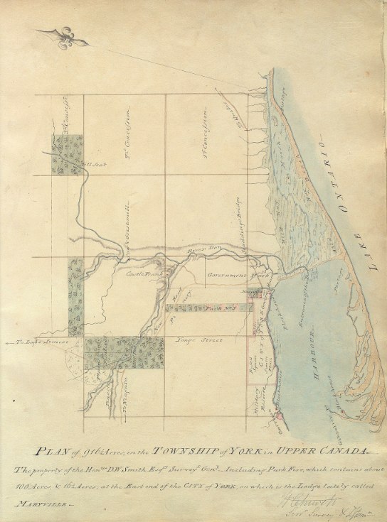
1802 Chewett: Plan of 916 1/4 acres, in the Township of York in Upper Canada -- The property of the Honble. D.W. Smith Esqre. Surveyr. Genl.

This 1802 map, drawn by William Chewett (the father of James Grant Chewett), depicts some of the extensive property owned by David W. Smith, the Surveyor General of Upper Canada who came to York as part of Simcoe’s entourage. The first parliament buildings are indicated by the notation, Govern: Houses, protected by a Blockhouse.

Of specific note is the Maryville estate, on which Smith established one of the town’s first major houses in 1796. The land, at King and Ontario to the east of the town, was purchased from John Kendrick. Smith was a master carpenter, and built the impressive structure according to his own tastes [Kendrick’s original house was subsumed and became the drawing room].

Click the image to view a full-size version. 

Plan of 916 1/4 acres, in the Township of York in Upper Canada. The property of the Honble. D.W. Smith, 1802 by William Chewett

Plan of 916 1/4 acres, in the Township of York in Upper Canada. The property of the Honble. D.W. Smith Esqre. Surveyr. Genl. - including Park Five, which contains about 100 acres, & 16 1/4 acres, at the east end of the city of York on which is the lodge lately called Maryville. [Sgd W. Chewett Senr Surveyr & Dftsmn

Image courtesy of Toronto Public Library: Ms1889.1.6
Winearls, MUC no. 2028

Maryville (also occasionally spelled 'Maryvale') Lodge was a large wooden Georgian-style house painted bright yellow (instead of the conventional white). Surrounding it were formal gardens and a circular driveway, and numerous support buildings.

Smith’s residency at Maryville did not last long: Smith departed Upper Canada for health reasons in 1802. One of the factors behind the existence of many records relating to Maryville was that Smith had them created as documentation for the attempted sale of the property, to CB Wyatt -- his successor in the Surveyor General post.

Chewett’s next map shows the layout of Maryville in some detail:


Plan of Maryville, at the east end of the City of York in Upper Canada, containing about 16 1/4 acres - the property of the Honble. D.W. Smith Esqre. Surveyor General. [Sgd] W Chewett Senr Surveyr & Dftsmn

Image courtesy of Toronto Public Library: Ms1889.1.7
Winearls, MUC no. 2027

Thomas Stoyell was the next occupant of Maryville Lodge, which later became a small private school. The house was demolished in 1854.

Following are two depictions of Maryville Lodge. The Poole painting gives an idea as to the yellow coloration of the structure.

Maryville Lodge circa 1805 by Charles W. Jefferys, “after drawing in Library's ms. collection, D. W. Smith Papers, vol.B15, p.90 (ca 1805). Reproduced (with clouds in a different hand added on a separate sheet mounted above drawing) in Evening Telegram series 'Landmarks of Toronto' 11 January 1889, and in Landmarks of Toronto v.1, p.287.”


Maryville Lodge painting by Frederic Poole, 1912 based on Jeffery’s drawing.


Images courtesy of Toronto Public Library: B 1-54b and JRR 521

Here’s a purported aerial sketch of the property:


See Also
1797 Smith Plan for the enlargement of York

More on Maryville Lodge:
See p21 onwards in Toronto: No Mean City by Eric Ross Arthur & Stephen A. Otto [there is a very detailed plan of the house itself and a front elevation by Chewett]

Please ‘Like’ and Share these maps with other Toronto history enthusiasts! (+1s are also welcome!)

Monday, February 11, 2013

1860 Tremaine's Map of the County of York, Canada West

George Tremaine compiled large wall maps of most of the counties of southern Ontario in the 1850s and 1860s. The maps identify names of owners or tenants, houses of subscribers, and names of estates. This map is for York County.

Small black squares indicate buildings such as residences, inns, schools, churches, and factories. Illustrations of major buildings border the right-side of the map. There is also a list of the names, professions and residences of subscribers to the map (Yes, the names are legible!).

An inset map of Toronto appears in section 1 below.

My genealogist friends seem to reference this map a lot, so I thought I had better include it [Can anyone point me to an online index of the names on the map? That would be a useful accompaniment I think].

Click on the image to view a full-size version of the [approximately] corresponding numbered area. 

Section1Section2Section3Section4Section5Section6Section9Section8Section7Section10Section11Section12Tremaine's Map of the County of York, Canada West, 1860

Tremaine’s Map of the County of York Canada West, Compiled and Drawn by Geo. R. Tremaine from Actual Surveys Toronto Published by Geo. C. Tremaine 1860

Images courtesy University of Toronto Map and Data Library: G3523 .Y6 1860 a. (See also: LAC). Winearls, MUC no. 404
[Thanks to Robannz for attempting to stitch it all together -- we tried making a monster file of all 12 sections, but it was too unwieldy to deal with.]


An advertisement for the Tremaines, appearing in the 1862 edition of The Canadian Almanac, W.C. Chewett & Co. I’m kind of curious to see what Tackabury’s map looked like, aren’t you?

Please ‘Like’ and Share these maps with other Toronto history enthusiasts! (+1s are also welcome!)

Sunday, February 10, 2013

ca. 1855 Magnus: City of Toronto

“This map was produced as letterhead for writing paper by Charles Magnus, a printer specializing in pictorial letterheads.

Whether the letterhead was commissioned by a stationer for general sale, or was designed for a single customer is not known. However, the 'X' on the map may mark the point from which the letter was written.

This map is an early example of the delineation of the shape of the built-up area, in this case by the use of hatched lines.”

- Isobel Ganton & Joan Winearls, MAPPING TORONTO'S FIRST CENTURY 1787-1884

Click the image to view a full-size version. 


City of Toronto C.W. Lithograph of Charles Magnus, ca. 1855; signed August 10, 1857.
Image courtesy of Stephen Otto.
Winearls, MUC no. 2127

Magnus also produced this view of the city, from atop the roof of the Jail at the foot of Parliament St. The corner of Front and Berkeley is in the right foreground:

Click the image to view a full-size version. 


Canada West. Toronto.
Published by Charles Magnus & Co., ca. late 1850s.
Image courtesy The Winterthur Library, Charles Magnus collection.

Magnus’ work here is almost certainly based on Edwin Whitefield’s Toronto, Canada West (see next image).

Whitefield’s 1854 bird's-eye view “illustrates a city of over 40,000 inhabitants centred along the harbour and the original City Hall, the site of today's South St. Lawrence Market and the Market Gallery. The busy harbour and Toronto's original shoreline came up to the back of City Hall, where The Esplanade is today. Not long after this image was created, the shoreline would undergo reclamation to allow for the railways.”
- City of Toronto, Market Gallery History

Some artistic liberties have been taken: the St. James and St. Michaels cathedral steeples were not actually completed until several years after this painting.

Click the image to view a full-size version. 


Toronto, Canada West. From the top of the Jail, by Edwin Whitefield, 1854.
Image courtesy City of Toronto Culture, A82-28 [See also: LAC]
[I’d love to get a larger version of this -- if anyone has a line on a better resolution print, let me know!]

A B&W key to Whitefield’s lithograph...

Click the image to view a full-size version:


Key to the Picture of Toronto In 1854 Showing Location of the Principal Buildings and Wharves
Image courtesy Toronto Public Library: B 4-68a

A photo-mechanical reproduction of the same drawing (with slight variations in the text) is in 'Landmarks of Toronto' v.5, facing p.578

“Charles Magnus was a print publisher, map dealer, bookseller and stationer working in New York City from 1850 to 1899 who issued over a thousand different letter sheets, maps, song sheets, envelopes, and separate prints. His best known works were city views and Civil War related material. Much of his work was copied from other printmakers. He often altered or combined design elements from several sources, rarely crediting the original artist. [Emph. added - N.] Many of his works after 1865 were based on photographs, which he often altered, drawing in figures or re-drawing lines for clearer reproduction.”

- The Winterthur Library, Magnus Finding Aid description

Gratuitous bonus - J.G. Howard’s 1836 watercolour of the Jail, from which the above perspective was supposedly taken:


Image courtesy Toronto Public Library: 938-1-2 Cab II

Gratuitous bonus 2Toronto, C.W., in the Summer of 1851 by Francis Hincks Granger.

View of Front St. from the Old Windmill to the Old Fort, giving a different perspective. For reference, the Gaol is #8. The artist, Francis Hincks Granger, was a scene painter for the Royal Lyceum Theatre, Toronto. He painted this watercolour "on the spot."


Image courtesy Toronto Public Library: JRR 341. A simple Key to the painting may be found here.

A black and white version may be found in John Ross Robertson’s Landmarks of Toronto (Vol II). His somewhat rambling key may be found here.


Please ‘Like’ and Share these maps with other Toronto history enthusiasts! (+1s are also welcome!)

Thursday, February 7, 2013

1818 Phillpotts Plan of York

‘Although this topographical plan was made by the military to record the overall defensive situation at York, it gives us an excellent picture of the amount of land that had been cleared and built-up by 1818. The Old Town was fairly densely settled, although the grounds around most houses were large enough to accommodate vegetable gardens, poultry, and livestock. Settlement in the New Town was still very sparse.

York was still essentially a village and had grown little since 1813, an indication that the area set aside for the town was for many years too big for the population.

To the north of Queen Street the small amount of clearing and settlement followed the streams and the narrow rectangular shape of the park lots.’
- Isobel Ganton & Joan Winearls, MAPPING TORONTO'S FIRST CENTURY 1787-1884

“Phillpott's map of Toronto may be considered one of the city's fundamental maps. The map graphically shows the development within the original city blocks as well as the newer developments to the west and north. The map bears the stamps of the Board of Ordnance and the Inspector General of Fortifications.”
- Library and Archives Canada description

Click the image to view a full-size version (PDF).


Plan of York Surveyed and Drawn by Lieut. Phillpotts, Royal Engineers.
Map courtesy Library and Archives Canada: NMC 17026. Winearls, MUC no. 2040 (2)

Although Phillpotts performed the survey in 1818, he did not draw the map until 1823.

‘George Phillpotts was a lieutenant in the Royal Engineers, when he made the fine 1818 map of Toronto. He was appointed aide-de-camp to Sir John Colborne in 1833 and was assistant Quartermaster General during the 1837 Rebellion.

The Royal Engineers were stationed in Toronto from the earliest period of British settlement and made reconnaissance sketches and topographical maps for the defense of Toronto as well as plans of the fort and military property. Unlike the civilian surveyors who were primarily concerned with property lines and boundaries, the military were more interested in the shape of the land and location of forested or cleared lands, passable roads, buildings, and other landmarks. Some of their maps of Toronto were the most detailed produced at the time.’ - Ganton/Winearls, ibid.

The following copy of the map was possibly done in 1907 (see archivist’s note, bottom left).

Click the image to view a full-size version (5 MB).

1818 Plan of York by Lieut. George Phillpotts

Original image scan courtesy City of Toronto Archives: MT 109Large version liberated by W. Xavier Snelgrove. See also the version posted by U of T.

For contrast, here is a third, differently coloured and lettered copy of the Phillpotts plan (it appears to be the most recent -- note 'copy of Stamp'):

Click the image to view a full-size version.

1818 Plan of York (Toronto) by G. Phillpotts - copy

Image courtesy Toronto Public Library: T1818-2/4Mlrg

Bonus
Here’s an almost cartoony version, created for J.R. Robertson’s Landmarks of Toronto:


Please ‘Like’ and Share these maps with other Toronto history enthusiasts! (+1s are also welcome!)

Monday, February 4, 2013

1882 City Engineer's Office: Plan of the city of Toronto, shewing proposed system of parks and boulevards to accompany Mayor McMurrich's report to council

What I find remarkable about this map is the presence and formative power of Toronto’s rivers. The Humber, Garrison Creek, Taddle Creek, the Don -- they snake through the city like pulsing veins, in marked contrast to the orderly grid surrounding them.

This fluid state would not last. In less than a decade, Garrison Creek and Taddle Creek would begin to be covered, while the straightening of the Don River (aka the ‘Don Improvement’ project) would turn out to be a massive engineering undertaking that cost twice as much as originally estimated.

Plan of the city of Toronto, shewing proposed system of parks and boulevards to accompany Mayor McMurrich's report to council, 11th November 1882. City Engineer’s Office.

Click the image to view a full-size version. 


Image courtesy of Toronto Public Library: T1882/4Mlrg
See also: LAC NMC19806

Mayor McMurrich went on to champion the Don Improvement project in the 1880s, taking inspiration from the straightening of the Cuyahoga River in Cleveland.

‘Pitched as a way to relieve the Don’s unsanitary state and bring shipping upriver, the ‘Don Improvement’ actually brought the Canadian Pacific Railway into downtown Toronto and created new land for industry on the flood plain in the late 1880s. Sheet-piling and filling eliminated the Don’s meandering course between the Grand Trunk rail corridor and Riverdale Park.’

- Chris Hardwicke & Wayne Reeves, Shapeshifters: Toronto’s changing watersheds, streams and shorelines in HTO

Click the image to view a full-size version. 


River Don Straightening Plan shewing Lands to be expropriated
Surveyors: Unwin, Browne & Sankey, May 7, 1888.

Image courtesy City of Toronto Archives, Series 725 File 12 (via York University)

Villiers Sankey was appointed as City Surveyor the same year as this map, and would go on to produce the 1902 Plan of the City of Toronto.

Please ‘Like’ and Share these maps with other Toronto history enthusiasts! (+1s are also welcome!)

1811 Wilmot Plan Shewing the Survey of the land Reserved for Government Buildings, East end of the Town of York

‘In 1811 the reserved land from Parliament Street to the Don River was still undeveloped. Originally it had been intended as a site for a naval dockyard, then for government buildings. In 1811 the government decided to divide the area into the [X acre?] lots shown here, which would be leased.

The low annual rental values assigned by Wilmot during his survey show his poor opinion of the lots. The plan was never implemented. In 1819 the area was granted to the new hospital (forerunner of Toronto General Hospital) to provide it with a source of income.

Note that King Street angled to the north in order to cross the Don River at a good bridging point - a path which it still follows.’

- Isobel Ganton & Joan Winearls, MAPPING TORONTO'S FIRST CENTURY 1787-1884

Click the image to view a full-size version.

1811 Wilmot Copy of Part of Plan of York: Survey of the land Reserved for Government Buildings

A Plan Shewing the Survey of the land Reserved for Government Buildings, East end of the Town of York, Surveyed by Order of His Excellency, Francis Gore, Esquire, Lieutenant Governor &c bearing date the 18th day of Decr. 1810. Feby 25 1811 [Sgd] Saml S[treet] Wilmot Dy Surveyor.

Source: Ontario Ministry of Natural Resources, Office of the Surveyor General: SR390 H26
Copyright:  2013 Queens Printer Ontario
Winearls, MUC no. 2033

See also: this subsequent copy of the plan, via Library and Archives Canada.


The following version is a copy created for J. Ross Robertson’s Landmarks of Toronto (may be a little clearer to read).

Click the image to view a full-size version.

1811 Wilmot Survey of the land reserved for government buildings, east of the town of York

A Plan Shewing the Survey of the land Reserved for Government Buildings, East end of the Town of York, Surveyed by Order of His Excellency, Francis Gore, Esquire, Lieutenant Governor &c bearing date the 18th day of Decr. 1810. Feby 25 1811 [Sgd] Saml S[treet] Wilmot Dy Surveyor.

Image courtesy Toronto Public Library: T1811/4Mlrg

‘The early surveyors were a small group of government employees who, under very difficult conditions, made the surveys of townships, townsites, and roads, so that settlement in Upper Canada could commence in an orderly manner.

For each survey, the Surveyor-General issued instructions which indicated the point where the survey was. to begin and the locations and bearings. of previously surveyed lines. The instructions also covered the dimensions of lots and road allowances and the planting of boundary posts.

The surveyor was required to keep careful field notes indicating each step of the survey and to record all measurements, as well as information on soils, types of trees, rivers, swamps, potential mill sites, squatters, and so on.

On completion of the survey, the surveyor was required to prepare a plan at one inch to 20 or to 40 chains, and to turn this in to the Surveyor-General along with his field notes. Many of the plans were later used to record the names of the settlers to whom land was allotted.

The basic instruments used by the surveyor were a circumferentor compass for sighting along the surveyed line, and a Gunter's chain for measuring the line (100 links in 1 chain equals 66 feet). A few surveyors had better instruments, such as a theodolite, which could be used for measuring horizontal and vertical angles.

There were many inaccuracies in the early surveys because the instruments were not precise, the terrain was rugged, and there was pressure on the surveyor to complete surveys quickly. In addition, the surveyors were not required to be trained and only some had a background in surveying or a knowledge of mathematics.’

- Ganton/Winearls, ibid.

Bonus Map for comparison

This sketch shows the first proposal for laying out lots east to the Don. The base plan was probably copied from those Stegmann made in 1799-1800. Note John Scadding’s land.


Sketch of Lots No 15 & 16 in the Broken Front of the Township of York. Copied from John Stegmann's Plan. W.C. [and] Sketch shewing two projects for laying out the Reserve for the Government Buildings at the East end of the Town of York with the relative situation ... W.C. 7th Decr 1810.

Source: Ontario Ministry of Natural Resources, Office of the Surveyor General: SR391 H26
Copyright:  2013 Queens Printer Ontario
Winearls, MUC no. 2032

Please ‘Like’ and Share these maps with other Toronto history enthusiasts! (+1s are also welcome!)