Friday, October 11, 2013

1837 Hawkins: Toronto Military Reserve [Feb. 1837]

Starting in 1833, Sir John Colborne oversaw a major expansion westward of the city, with the sale of over 200 acres of the Military Reserve adjoining Fort York east of Garrison Creek, in order to fund the construction of a new fort. The following, final official plan for the area documents the result of that process, and is packed with the names of lot owners and corresponding lot numbers.

Click the image to view a full-size version (PDF). 


Toronto Military Reserve. Resurvey by Wm Hawkins Dy. Surveyor. By order of His Excellency Sir Francis B. Head Lieut. Governor U. Canada &c &c &c as laid out in Town Lots on the east of the Ravine. [Sgd] To the Honble John Macaulay Surveyor General &c &c &c Toronto William Hawkins Dy Surveyor Toronto 18th Feby 1837 [Certified and sgd] R.H. Bonnycastle Captn Royal Engineers Western District U.C. 21st Feby 1837

Source: Ontario Ministry of Natural Resources, Office of the Surveyor General: 348-H24
© 2013 Queens Printer Ontario
Winearls, MUC no. 2064 (15)

See the 1797 Smith Plan for the enlargement of York for the previous major town expansion.

Please ‘Like’ and Share these maps with other Toronto history enthusiasts! (+1s are also welcome!)

Explore Toronto's past through maps...

Featuring simple and free access to a broad selection of notable historical maps of Toronto, this site aims to generate curiosity, and to serve as an easy entry point for discovery and further investigation.

1818 Lieut. G. Phillpotts: Plan of York
How did ‘Muddy York’ develop into the modern metropolis we live in?

These important maps from our past reveal the essential tension of this city — between the quest for growth, and the heavy influence of what came before. They reflect a municipality in constant flux, and give insight into our contemporary urban identity.

And besides, who doesn’t love poring over old maps of Toronto?

- Nathan Ng, April 2013.

Start your exploration—complete list of maps
More about this project...

Monday, October 7, 2013

1852 Liddy: [I]ncorporated Village of Yorkville in the County of York and Province of Canada

“The generous limits of Yorkville at incorporation show that the boom mentality prevailed even in a village so small that its urban landowners could all be listed on the sides of the map. Different patterns of transitional subdivision are evident along Yonge Street and Avenue Road to the west; these patterns had already begun to determine the location of urban streets.

The map, although somewhat resembling folk-art in the representation of the trees and the brickyard, shows the influence of the British Ordnance Survey in the patterning of fields. Note the early idea for a rectangular plan in part of the Rosedale estate (right centre), soon to be superseded by a dramatically different plan.”

- Isobel Ganton & Joan Winearls, MAPPING TORONTO'S FIRST CENTURY 1787-1884

Click the image to view a full-size version (PDF, 3MB). 


[I]ncorporated Village of Yorkville in the County of York and Province of Canada. 
Drawn from an actual Survey by G.P. Liddy Late of the Engineering Department of the Ordnance Survey of Great Britain and Ireland. Provincial Land Surveyor, Civil Engineer etc. [Sgd] Geo. P. L[iddy]

Source: Ontario Ministry of Natural Resources, Office of the Surveyor General: SR7017
Copyright:  2013 Queens Printer Ontario
Winearls, MUC no. 2091

Yorkville was incorporated January 1, 1853.


Please ‘Like’ and Share these maps with other Toronto history enthusiasts! (+1s are also welcome!)

Thursday, September 5, 2013

1868 Gehle, Fawkes & Hassard: Reconnaissance Sketches of Toronto Area

‘These reconnaissance maps were made to help the military to meet the threat of raids by the American-based Fenians on Toronto, now the capital of the new Province of Ontario. The military nature of the maps is evident (see "References") in the type of information recorded: roads passable for artillery, farms able to supply horses and to accommodate soldiers, and sources of fresh water.

These maps are the first to show the topography of the region in detail. They reveal the close relationship between river valleys and uncleared land. The routing of roads around physical barriers is clear as well.

Although most major buildings are shown, only those important to the military, such as the taverns and hotels along the roads out of town, are identified. A few industrial sites, such as the brickyards along Kingston Road and in Yorkville, are also noted.

Two Royal Engineers produced this set of maps. The difference in their styles is evident...’

- Isobel Ganton & Joan Winearls, MAPPING TORONTO'S FIRST CENTURY 1787-1884

Click the images to view full-size versions (PDF). 


Sketch Sheets of a Winter Reconnaissance of the Country W. of Toronto to the Humber River, and North to the Davenport Road
[Surveyed by:] H.J.W. [Henry John Wolsteyn] Gehle, Lt. R.E. 11/1/68
[Signed] F.C. [Fairfax Charles] Hassard, Lt. Col. 15/1/68

Image courtesy of Library and Archives Canada: NMC20712

Note in the above map the Sandy beach, good landing for boats (Americans landed here in 1812).


Sketch Sheet of a Reconnaissance of Ground in the neighbourhood of Toronto lying in the 2nd and 3rd Concessions from the Bay, east and west of Yonge Street. December Quarter 1868

[Surveyor:] F.H. Fawkes, Lt. R.E. 22.1.69
[Signature] F.C. Hassard, Col. R.E. 26.1.69

Image courtesy of Library and Archives Canada: NMC20710


Sketch Sheets of a Winter Reconnaissance of the Country East of Toronto, between the Don River; & the Township of Scarboro, on the E. & the Don & Danforth Road. on the N. to the Lake Shore. Office Copy - original to Montreal, 20 Apl. 68. 
[Surveyor:] H.J.W. Gehle, Lt. R.E. 17/Apl. 68.

Image courtesy of Library and Archives Canada: NMC20711


Sketch of a Reconnaissance of ground in the neighbourhood of Toronto being the Eastern extremity of the 2nd and 3rd Concessions from the Bay  [This map is essentially the eastern continuation of NMC20710 above. -N.]

Surveyed by: F.H. Fawkes, Lt. R.E., June Quarter 1869.
F.C. Hassard, Lt. Col. R.E. 20 August, 1869.

Image courtesy of Library and Archives Canada: NMC22847 [via Derek Hayes’ Historical Atlas of Toronto]

Research Note: There is one additional map in this set I have not [yet] been able to procure: Sketch sheet of a Reconnaissance of Ground in the Neigbourhood of Toronto Lying principally in the Third Concession from the Bay and Extending from Humber Eastward (NMC22845)

Bonus: Etobicoke


Toronto District Sketch Sheets of a Reconnaissance of the Country between the rivers Humber and Etobicoke from the shore of Lake Ontario to Dundas Street on the North.  1867. [Sgd] H.J.W. Gehle, Lt. R.E., 16/7/67

Note: Unfortunately the only high-resolution scan available is in black and white.
Color Thumbnail courtesy Library and Archives Canada: NMC26685
B&W expanded Scan courtesy University of Toronto Map and Data Library: NMC26685


Sketch Sheets of a Reconnaissance in the County of York, Township of Etobicoke, between the Humber & Etobicoke Rivers, N. of Dundas Street 
[Sgd] H.J.W. Gehle, Lt. R.E. 16/10/67.

Image courtesy University of Toronto Map and Data Library: NMC26681. [LAC record: NMC26681]

Please ‘Like’ and Share these maps with other Toronto history enthusiasts! (+1s are also welcome!)

Saturday, August 17, 2013

1859 University of Toronto Campus / Queen’s Park [Plan of the University Park]

The University of Toronto / King’s College / University College
‘The university land had been little developed since its purchase in 1829 [by Bishop Strachan]. King’s College ['The Asylum', lower right] had been built in 1842, but was later used as a lunatic asylum. In 1854 the eastern part of the site (now Queen’s Park) was proposed as the location for new provincial parliament buildings [but nothing was built until 1886; see 2nd map below. -N.].

University College was opened in 1859 and some of the curving drives were added in that year. Taddle Creek, prominently shown in the middle, was polluted with sewage from Yorkville by the 1870s and remained a bone of contention between city and university until it was covered over in the 1880s.’

- Isobel Ganton & Joan Winearls, MAPPING TORONTO'S FIRST CENTURY 1787-1884

Click the image to view a full-size version. 


Campus Map of area bounded by College, St. George, Bloor and Surrey Place [Plan of the University Park], c. 1859
Map courtesy of: University of Toronto Archives, 2003-42-3f [A1965-0001(20)]
Winearls, MUC no. 2103 (2)

Queen’s Park
In 1854 the eastern portion of the university lands was the proposed location for the new legislature buildings, as reflected in this earlier map by John Stoughton Dennis (see next) showing nearby lots for sale from the Denison estate. It was then hoped that Toronto would be chosen by Queen Victoria as the permanent capital of the Province of Canada. Due to a lack of funds (and Toronto being passed over in favour of Ottawa), the depicted plan by Cumberland and Ridout for the Parliament Buildings “about to be erected” was never built.

Click the image to view a full-size version. 


Plan of Part of the City of Toronto Shewing the Town Lots on Bellevue For Sale by the Trustees for the Denison Estate March 1854
John Stoughton Dennis P.L.S. Maclear & Co. Lith. Toronto
Map courtesy of Toronto Public Library: T1854/4Msm
Winearls, MUC no. 2105

In 1859 the University leased 49 acres—an area encompassing the present day Ontario Legislature, parts of the modern day university campus, and portions of College Street and University Avenue—to the City of Toronto for a period of 999 years, to create a public park. Queen’s Park was officially opened by the Prince of Wales on September 11, 1860.

It would take decades to revive the notion of erecting legislature buildings on the site [see next map]. In 1880, the southern portion of the Park was turned over to the Province of Ontario for construction. Observe how the former King's College building, used as the 'University Lunatic Asylum' until 1869, is now merely labelled 'Old Building to be Removed'.

Click the image to view a full-size version. 


Site of the proposed parliament buildings, Ontario. Queen's Park.
Department of Public Works, Ontario. Toronto, April 7, 1880
Map courtesy of Toronto Public Library: T1880/4Mlrg

Supplementary Photos — View from University College
I came across this set of four remarkable photos taken in 1859 by William Notman, from the top of University College. The views they depict correspond to a large section of the 1859 map of the campus.

Looking east from University College to King’s College/
the University Lunatic Asylum

Looking south east to the Moss Hall (the Medical Building).
The closer structure is the residence of George Kingston,
the Director of the Observatory.

Looking south to the Magnetic Observatory (in its original location)

Looking north towards Yorkville

Reference: see E 9-277 and E 9-278. Note: I only confirmed the provenance for these two photos, but am inclined to believe that the other two are also Notman’s. Please let me know if there is evidence to the contrary!

Bonus Map — 1852 Exhibition Grounds
The following map shows the Exhibition Grounds in 1852,  located that year a little south of Queen’s Park along the west side of College Avenue (a.k.a. University).


Sketch of the Exhibition Grounds, Toronto
Lithograph by S.A.F. in Canadian Journal v.1, no.3 (October 1852) facing p. 49.
Map courtesy of Toronto Public Library: JRR 3539

Further reading on Queen’s Park:
Queen’s Park - Via Ontario Heritage Trust.

Please ‘Like’ and Share these maps with other Toronto history enthusiasts! (+1s are also welcome!)

Sunday, June 23, 2013

1817 Smith: Plan of York, U.C. & 1818 Plan of the Town of York

This map was surveyed and drawn by Lieut. E.A. Smith of the 70th Infantry, and provided to Sir John Coape Sherbrooke, the Governor General of British North America at the time (via the Quartermaster General’s Office, Upper Canada).

Numerous key structures are noted, including the Garrison, Gibraltar Point Lighthouse, the Government House, and the ravine Blockhouse (roughly where Trinity Bellwoods Park is). As well, the estates of several leading citizens are indicated. The Smith map was part of a historically significant collection of Sherbrooke’s papers purchased at auction in June 2013 by Library and Archives Canada.

Click the image to view a full-size version. 


Plan of York, U.C. / Surveyed and Drawn August 1817, by Lieut. E.A. Smith, 70th Inf'y
Image courtesy of Library and Archives Canada
[Note: Winearls, MUC no. 2041 is a later, but smaller and less detailed version of this plan, prepared for Sherbrooke's successor, Lord Dalhousie. It is held by the William Inglis Morse Collection at Acadia University: 1931.004-WIM/58]

The next plan from the following year is provided as a supplement. It shows the names of lot owners for the town including park lots.

Click the image to view a full size version.


Plan of the Town of York W.C. [9 June 1818]
Image courtesy Toronto Public Library: T1816-3/4Mlrg. Winearls, MUC no. 2044

It’s worth taking the time to compare the above maps with the two Williams plans, and the 1818 Phillpotts Plan of York.


Please ‘Like’ and Share these maps with other Toronto history enthusiasts! (+1s are also welcome!)

Monday, March 25, 2013

1886 Wesbroom: City of Toronto [Bird’s Eye View]

“This bird’s eye view [...] shows more clearly than either maps or streetscape photographs the congestion of the downtown core and the unrelenting zeal with which the grid pattern of streets—first laid out for Simcoe in 1793—had been stretched across the landscape on either side of the arrow-straight line of Yonge. Standing out against this pattern are the few attempts to mitigate the worst aspects of the grid plan: natural changes like King Street / Kingston Road, which turns northeast on the right side of the view; the carefully planned avenues like Spadina (with its crescent at the north end) and University; and the park-like green spaces scattered throughout the city [...]

If proof were needed that the Victorians, just as much as the Georgians, were proud and capable city builders, this bird’s eye view provides it amply. A celebration of their creation, it is a lasting testimony of what had been created in Toronto.”

- William Dendy, Lost Toronto

Click the image to view a full-size version. 

City of Toronto [Bird’s Eye View], 1886, W. Wesbroom

City of Toronto
Lithograph by W. Wesbroom, 1886 (? see note below)
Toronto Lithographing Company

Image courtesy Toronto Public Library: CHPC accession number 975-29 Cab III. Another copy is held by the Thomas Fisher Rare Books Library at U of T: G3524 .T61 1886. The image above is a photograph I took in person; if and when the TPL digitizes the map I’ll use their scan.

The Toronto Lithographing Company seems to have done especially fine work, wouldn’t you say?
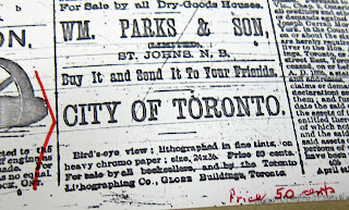
1886 Globe advertisement for Wesbroom Bird's Eye View of Toronto map
Advertisement: The Globe, May 22, 1886 

Note: Dendy’s Lost Toronto — which uses this bird’s eye view as its cover — gives an approximate date of 1878. Derek Hayes’ Historical Atlas of Toronto indicates 1884. These may be slightly different prints, or they may be the same and there just isn’t agreement on the actual date...

The Osborne Collection at the Toronto Public Library (Lillian H. Smith branch) features this cropped jigsaw puzzle of the map in their Canadiana holdings:

Wesbroom Bird's eye view of Toronto: jigsaw puzzle

Lovely.

See Also [Bird’s Eye Views]
1870 Canadian Railway News Bird’s Eye View of Toronto
1876 PA Gross Bird's Eye View of Toronto
1876 Gascard City of Toronto Bird’s Eye View from the Northern Railway elevator
1892 Toronto Railway Company Map Shewing Toronto Street Railway Lines
1893 Barclay, Clark & Co. Bird’s Eye View Chromolithograph

Please ‘Like’ and Share these maps with other Toronto history enthusiasts! (+1s are also welcome!)