Wednesday, February 20, 2013

1834 Bonnycastle/Tazewell: City of Toronto: The Capital of Upper Canada

Act to Incorporate the City of Toronto, March 6, 1834
Act to Incorporate Toronto
Courtesy TPL: 352.07135 T5916 BR
“The Town of York was incorporated as the City of Toronto on March 6, 1834, and this map was produced to record the event. It was the first separately published map of the city. The boundaries of the city and its liberties -- areas appended to the city to provide room for expansion -- are shown in the small inset map. The northern boundary of the city proper was 400 yards north of Queen Street [aka Lot Street -N.], an indication that the southern part of the park lots had been developed by the early 1830s.

Note the clusters of public buildings: those of municipal significance east of Yonge at the edge of the Old Town and the provincial buildings in the New Town. The "Lands Reserved for a Public Pleasure Ground" and a "Proposed Esplanade" on the waterfront indicate an early interest in keeping the area for recreational uses.”

- Isobel Ganton & Joan Winearls, MAPPING TORONTO'S FIRST CENTURY 1787-1884

City of Toronto: The Capital of Upper Canada 1834
Respectfully dedicated to His Excellency Sir John Colborne K.C.B. &c // by H.W.J. Bonnycastle and lithographed by S.O. Tazewell.
Winearls, MUC no. 2066

Re-drawn 1919 by Wm. R. Gregg.

Click the image to view a full-size version. 

1834 Bonnycastle/Tazewell City of Toronto: The Capital of Upper Canada

Image courtesy of Toronto Public Library (though it’s not in the Catalogue as of Feb 2013, ahem. It’s from the Special Collections Dept. I had to do a bit of extraction work...): An Act of Incorporation.

“Samuel Oliver Tazewell, formerly a Kingston watchmaker and jeweller, introduced the new art of lithography to Canada and produced his first lithographed map in 1831.

Lithography is a method of printing from an image on the surface of a stone. Requiring less skill than copper-plate engraving, it was ideal for maps because the draftsman could draw directly on the stone or transfer a map from paper to the stone.

Tazewell built his own press and used local stone, both of which may have contributed to the roughness of his printing (note the map to the left). However, the newspapers of the day (see the Patriot, 11 Apr. 1834) hailed the new printing method for its speedy production of multiple copies and noted its particular usefulness. for advertising lots for sale.”

“Henry William John Bonnycastle (1814-1888) was the son of R.H. Bonnycastle, and the 1834 map of Toronto that he drew is closely related to the 1833 plan prepared by his father. Educated at Upper Canada College and Sandhurst, he served as a Brigade Major during the 1837 Rebellion.”

- Ganton/Winearls, ibid.

This following map drafted by  J. G. Chewett was drawn up 3 years later, and similarly runs from the Military Reserve to the Don River, north to Lot St.

Click the image to view a full-size version.

Toronto. by J.W. Macaulay. Surveyor General's Office Toronto 12th June 1837

Toronto. [Sgd] J.G. Chewett S.G. Office 12th June 1837; Surveyor General’s Office Toronto 12th June 1837 J.W. Macaulay Survr Genl
Image courtesy Toronto Public Library: MsX.1921.2. Winearls, MUC no. 2072

See Also
1834 Chewett Plan of the City of Toronto and Liberties

Please ‘Like’ and Share these maps with other Toronto history enthusiasts! (+1s are also welcome!)

Monday, February 18, 2013

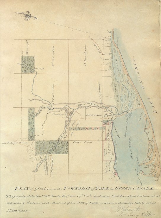
1802 Chewett: Plan of 916 1/4 acres, in the Township of York in Upper Canada -- The property of the Honble. D.W. Smith Esqre. Surveyr. Genl.

This 1802 map, drawn by William Chewett (the father of James Grant Chewett), depicts some of the extensive property owned by David W. Smith, the Surveyor General of Upper Canada who came to York as part of Simcoe’s entourage. The first parliament buildings are indicated by the notation, Govern: Houses, protected by a Blockhouse.

Of specific note is the Maryville estate, on which Smith established one of the town’s first major houses in 1796. The land, at King and Ontario to the east of the town, was purchased from John Kendrick. Smith was a master carpenter, and built the impressive structure according to his own tastes [Kendrick’s original house was subsumed and became the drawing room].

Click the image to view a full-size version. 

Plan of 916 1/4 acres, in the Township of York in Upper Canada. The property of the Honble. D.W. Smith, 1802 by William Chewett

Plan of 916 1/4 acres, in the Township of York in Upper Canada. The property of the Honble. D.W. Smith Esqre. Surveyr. Genl. - including Park Five, which contains about 100 acres, & 16 1/4 acres, at the east end of the city of York on which is the lodge lately called Maryville. [Sgd W. Chewett Senr Surveyr & Dftsmn

Image courtesy of Toronto Public Library: Ms1889.1.6
Winearls, MUC no. 2028

Maryville (also occasionally spelled 'Maryvale') Lodge was a large wooden Georgian-style house painted bright yellow (instead of the conventional white). Surrounding it were formal gardens and a circular driveway, and numerous support buildings.

Smith’s residency at Maryville did not last long: Smith departed Upper Canada for health reasons in 1802. One of the factors behind the existence of many records relating to Maryville was that Smith had them created as documentation for the attempted sale of the property, to CB Wyatt -- his successor in the Surveyor General post.

Chewett’s next map shows the layout of Maryville in some detail:


Plan of Maryville, at the east end of the City of York in Upper Canada, containing about 16 1/4 acres - the property of the Honble. D.W. Smith Esqre. Surveyor General. [Sgd] W Chewett Senr Surveyr & Dftsmn

Image courtesy of Toronto Public Library: Ms1889.1.7
Winearls, MUC no. 2027

Thomas Stoyell was the next occupant of Maryville Lodge, which later became a small private school. The house was demolished in 1854.

Following are two depictions of Maryville Lodge. The Poole painting gives an idea as to the yellow coloration of the structure.

Maryville Lodge circa 1805 by Charles W. Jefferys, “after drawing in Library's ms. collection, D. W. Smith Papers, vol.B15, p.90 (ca 1805). Reproduced (with clouds in a different hand added on a separate sheet mounted above drawing) in Evening Telegram series 'Landmarks of Toronto' 11 January 1889, and in Landmarks of Toronto v.1, p.287.”


Maryville Lodge painting by Frederic Poole, 1912 based on Jeffery’s drawing.


Images courtesy of Toronto Public Library: B 1-54b and JRR 521

Here’s a purported aerial sketch of the property:


See Also
1797 Smith Plan for the enlargement of York

More on Maryville Lodge:
See p21 onwards in Toronto: No Mean City by Eric Ross Arthur & Stephen A. Otto [there is a very detailed plan of the house itself and a front elevation by Chewett]

Please ‘Like’ and Share these maps with other Toronto history enthusiasts! (+1s are also welcome!)
Monday, February 11, 2013

1860 Tremaine's Map of the County of York, Canada West

George Tremaine compiled large wall maps of most of the counties of southern Ontario in the 1850s and 1860s. The maps identify names of owners or tenants, houses of subscribers, and names of estates. This map is for York County.

Small black squares indicate buildings such as residences, inns, schools, churches, and factories. Illustrations of major buildings border the right-side of the map. There is also a list of the names, professions and residences of subscribers to the map (Yes, the names are legible!).

An inset map of Toronto appears in section 1 below.

My genealogist friends seem to reference this map a lot, so I thought I had better include it [Can anyone point me to an online index of the names on the map? That would be a useful accompaniment I think].

Click on the image to view a full-size version of the [approximately] corresponding numbered area. 

Section1Section2Section3Section4Section5Section6Section9Section8Section7Section10Section11Section12Tremaine's Map of the County of York, Canada West, 1860

Tremaine’s Map of the County of York Canada West, Compiled and Drawn by Geo. R. Tremaine from Actual Surveys Toronto Published by Geo. C. Tremaine 1860

Images courtesy University of Toronto Map and Data Library: G3523 .Y6 1860 a. (See also: LAC). Winearls, MUC no. 404
[Thanks to Robannz for attempting to stitch it all together -- we tried making a monster file of all 12 sections, but it was too unwieldy to deal with.]


An advertisement for the Tremaines, appearing in the 1862 edition of The Canadian Almanac, W.C. Chewett & Co. I’m kind of curious to see what Tackabury’s map looked like, aren’t you?

Please ‘Like’ and Share these maps with other Toronto history enthusiasts! (+1s are also welcome!)

Sunday, February 10, 2013

ca. 1855 Magnus: City of Toronto

“This map was produced as letterhead for writing paper by Charles Magnus, a printer specializing in pictorial letterheads.

Whether the letterhead was commissioned by a stationer for general sale, or was designed for a single customer is not known. However, the 'X' on the map may mark the point from which the letter was written.

This map is an early example of the delineation of the shape of the built-up area, in this case by the use of hatched lines.”

- Isobel Ganton & Joan Winearls, MAPPING TORONTO'S FIRST CENTURY 1787-1884

Click the image to view a full-size version. 


City of Toronto C.W. Lithograph of Charles Magnus, ca. 1855; signed August 10, 1857.
Image courtesy of Stephen Otto.
Winearls, MUC no. 2127

Magnus also produced this view of the city, from atop the roof of the Jail at the foot of Parliament St. The corner of Front and Berkeley is in the right foreground:

Click the image to view a full-size version. 


Canada West. Toronto.
Published by Charles Magnus & Co., ca. late 1850s.
Image courtesy The Winterthur Library, Charles Magnus collection.

Magnus’ work here is almost certainly based on Edwin Whitefield’s Toronto, Canada West (see next image).

Whitefield’s 1854 bird's-eye view “illustrates a city of over 40,000 inhabitants centred along the harbour and the original City Hall, the site of today's South St. Lawrence Market and the Market Gallery. The busy harbour and Toronto's original shoreline came up to the back of City Hall, where The Esplanade is today. Not long after this image was created, the shoreline would undergo reclamation to allow for the railways.”
- City of Toronto, Market Gallery History

Some artistic liberties have been taken: the St. James and St. Michaels cathedral steeples were not actually completed until several years after this painting.

Click the image to view a full-size version. 


Toronto, Canada West. From the top of the Jail, by Edwin Whitefield, 1854.
Image courtesy City of Toronto Culture, A82-28 [See also: LAC]
[I’d love to get a larger version of this -- if anyone has a line on a better resolution print, let me know!]

A B&W key to Whitefield’s lithograph...

Click the image to view a full-size version:


Key to the Picture of Toronto In 1854 Showing Location of the Principal Buildings and Wharves
Image courtesy Toronto Public Library: B 4-68a

A photo-mechanical reproduction of the same drawing (with slight variations in the text) is in 'Landmarks of Toronto' v.5, facing p.578

“Charles Magnus was a print publisher, map dealer, bookseller and stationer working in New York City from 1850 to 1899 who issued over a thousand different letter sheets, maps, song sheets, envelopes, and separate prints. His best known works were city views and Civil War related material. Much of his work was copied from other printmakers. He often altered or combined design elements from several sources, rarely crediting the original artist. [Emph. added - N.] Many of his works after 1865 were based on photographs, which he often altered, drawing in figures or re-drawing lines for clearer reproduction.”

- The Winterthur Library, Magnus Finding Aid description

Gratuitous bonus - J.G. Howard’s 1836 watercolour of the Jail, from which the above perspective was supposedly taken:


Image courtesy Toronto Public Library: 938-1-2 Cab II

Gratuitous bonus 2Toronto, C.W., in the Summer of 1851 by Francis Hincks Granger.

View of Front St. from the Old Windmill to the Old Fort, giving a different perspective. For reference, the Gaol is #8. The artist, Francis Hincks Granger, was a scene painter for the Royal Lyceum Theatre, Toronto. He painted this watercolour "on the spot."


Image courtesy Toronto Public Library: JRR 341. A simple Key to the painting may be found here.

A black and white version may be found in John Ross Robertson’s Landmarks of Toronto (Vol II). His somewhat rambling key may be found here.


Please ‘Like’ and Share these maps with other Toronto history enthusiasts! (+1s are also welcome!)

Thursday, February 7, 2013

1818 Phillpotts Plan of York

‘Although this topographical plan was made by the military to record the overall defensive situation at York, it gives us an excellent picture of the amount of land that had been cleared and built-up by 1818. The Old Town was fairly densely settled, although the grounds around most houses were large enough to accommodate vegetable gardens, poultry, and livestock. Settlement in the New Town was still very sparse.

York was still essentially a village and had grown little since 1813, an indication that the area set aside for the town was for many years too big for the population.

To the north of Queen Street the small amount of clearing and settlement followed the streams and the narrow rectangular shape of the park lots.’
- Isobel Ganton & Joan Winearls, MAPPING TORONTO'S FIRST CENTURY 1787-1884

“Phillpott's map of Toronto may be considered one of the city's fundamental maps. The map graphically shows the development within the original city blocks as well as the newer developments to the west and north. The map bears the stamps of the Board of Ordnance and the Inspector General of Fortifications.”
- Library and Archives Canada description

Click the image to view a full-size version (PDF).


Plan of York Surveyed and Drawn by Lieut. Phillpotts, Royal Engineers.
Map courtesy Library and Archives Canada: NMC 17026. Winearls, MUC no. 2040 (2)

Although Phillpotts performed the survey in 1818, he did not draw the map until 1823.

‘George Phillpotts was a lieutenant in the Royal Engineers, when he made the fine 1818 map of Toronto. He was appointed aide-de-camp to Sir John Colborne in 1833 and was assistant Quartermaster General during the 1837 Rebellion.

The Royal Engineers were stationed in Toronto from the earliest period of British settlement and made reconnaissance sketches and topographical maps for the defense of Toronto as well as plans of the fort and military property. Unlike the civilian surveyors who were primarily concerned with property lines and boundaries, the military were more interested in the shape of the land and location of forested or cleared lands, passable roads, buildings, and other landmarks. Some of their maps of Toronto were the most detailed produced at the time.’ - Ganton/Winearls, ibid.

The following copy of the map was possibly done in 1907 (see archivist’s note, bottom left).

Click the image to view a full-size version (5 MB).

1818 Plan of York by Lieut. George Phillpotts

Original image scan courtesy City of Toronto Archives: MT 109Large version liberated by W. Xavier Snelgrove. See also the version posted by U of T.

For contrast, here is a third, differently coloured and lettered copy of the Phillpotts plan (it appears to be the most recent -- note 'copy of Stamp'):

Click the image to view a full-size version.

1818 Plan of York (Toronto) by G. Phillpotts - copy

Image courtesy Toronto Public Library: T1818-2/4Mlrg

Bonus
Here’s an almost cartoony version, created for J.R. Robertson’s Landmarks of Toronto:


Please ‘Like’ and Share these maps with other Toronto history enthusiasts! (+1s are also welcome!)

Monday, February 4, 2013

1882 City Engineer's Office: Plan of the city of Toronto, shewing proposed system of parks and boulevards to accompany Mayor McMurrich's report to council

What I find remarkable about this map is the presence and formative power of Toronto’s rivers. The Humber, Garrison Creek, Taddle Creek, the Don -- they snake through the city like pulsing veins, in marked contrast to the orderly grid surrounding them.

This fluid state would not last. In less than a decade, Garrison Creek and Taddle Creek would begin to be covered, while the straightening of the Don River (aka the ‘Don Improvement’ project) would turn out to be a massive engineering undertaking that cost twice as much as originally estimated.

Plan of the city of Toronto, shewing proposed system of parks and boulevards to accompany Mayor McMurrich's report to council, 11th November 1882. City Engineer’s Office.

Click the image to view a full-size version. 


Image courtesy of Toronto Public Library: T1882/4Mlrg
See also: LAC NMC19806

Mayor McMurrich went on to champion the Don Improvement project in the 1880s, taking inspiration from the straightening of the Cuyahoga River in Cleveland.

‘Pitched as a way to relieve the Don’s unsanitary state and bring shipping upriver, the ‘Don Improvement’ actually brought the Canadian Pacific Railway into downtown Toronto and created new land for industry on the flood plain in the late 1880s. Sheet-piling and filling eliminated the Don’s meandering course between the Grand Trunk rail corridor and Riverdale Park.’

- Chris Hardwicke & Wayne Reeves, Shapeshifters: Toronto’s changing watersheds, streams and shorelines in HTO

Click the image to view a full-size version. 


River Don Straightening Plan shewing Lands to be expropriated
Surveyors: Unwin, Browne & Sankey, May 7, 1888.

Image courtesy City of Toronto Archives, Series 725 File 12 (via York University)

Villiers Sankey was appointed as City Surveyor the same year as this map, and would go on to produce the 1902 Plan of the City of Toronto.

Please ‘Like’ and Share these maps with other Toronto history enthusiasts! (+1s are also welcome!)

1811 Wilmot Plan Shewing the Survey of the land Reserved for Government Buildings, East end of the Town of York

‘In 1811 the reserved land from Parliament Street to the Don River was still undeveloped. Originally it had been intended as a site for a naval dockyard, then for government buildings. In 1811 the government decided to divide the area into the [X acre?] lots shown here, which would be leased.

The low annual rental values assigned by Wilmot during his survey show his poor opinion of the lots. The plan was never implemented. In 1819 the area was granted to the new hospital (forerunner of Toronto General Hospital) to provide it with a source of income.

Note that King Street angled to the north in order to cross the Don River at a good bridging point - a path which it still follows.’

- Isobel Ganton & Joan Winearls, MAPPING TORONTO'S FIRST CENTURY 1787-1884

Click the image to view a full-size version.

1811 Wilmot Copy of Part of Plan of York: Survey of the land Reserved for Government Buildings

A Plan Shewing the Survey of the land Reserved for Government Buildings, East end of the Town of York, Surveyed by Order of His Excellency, Francis Gore, Esquire, Lieutenant Governor &c bearing date the 18th day of Decr. 1810. Feby 25 1811 [Sgd] Saml S[treet] Wilmot Dy Surveyor.

Source: Ontario Ministry of Natural Resources, Office of the Surveyor General: SR390 H26
Copyright:  2013 Queens Printer Ontario
Winearls, MUC no. 2033

See also: this subsequent copy of the plan, via Library and Archives Canada.


The following version is a copy created for J. Ross Robertson’s Landmarks of Toronto (may be a little clearer to read).

Click the image to view a full-size version.

1811 Wilmot Survey of the land reserved for government buildings, east of the town of York

A Plan Shewing the Survey of the land Reserved for Government Buildings, East end of the Town of York, Surveyed by Order of His Excellency, Francis Gore, Esquire, Lieutenant Governor &c bearing date the 18th day of Decr. 1810. Feby 25 1811 [Sgd] Saml S[treet] Wilmot Dy Surveyor.

Image courtesy Toronto Public Library: T1811/4Mlrg

‘The early surveyors were a small group of government employees who, under very difficult conditions, made the surveys of townships, townsites, and roads, so that settlement in Upper Canada could commence in an orderly manner.

For each survey, the Surveyor-General issued instructions which indicated the point where the survey was. to begin and the locations and bearings. of previously surveyed lines. The instructions also covered the dimensions of lots and road allowances and the planting of boundary posts.

The surveyor was required to keep careful field notes indicating each step of the survey and to record all measurements, as well as information on soils, types of trees, rivers, swamps, potential mill sites, squatters, and so on.

On completion of the survey, the surveyor was required to prepare a plan at one inch to 20 or to 40 chains, and to turn this in to the Surveyor-General along with his field notes. Many of the plans were later used to record the names of the settlers to whom land was allotted.

The basic instruments used by the surveyor were a circumferentor compass for sighting along the surveyed line, and a Gunter's chain for measuring the line (100 links in 1 chain equals 66 feet). A few surveyors had better instruments, such as a theodolite, which could be used for measuring horizontal and vertical angles.

There were many inaccuracies in the early surveys because the instruments were not precise, the terrain was rugged, and there was pressure on the surveyor to complete surveys quickly. In addition, the surveyors were not required to be trained and only some had a background in surveying or a knowledge of mathematics.’

- Ganton/Winearls, ibid.

Bonus Map for comparison

This sketch shows the first proposal for laying out lots east to the Don. The base plan was probably copied from those Stegmann made in 1799-1800. Note John Scadding’s land.


Sketch of Lots No 15 & 16 in the Broken Front of the Township of York. Copied from John Stegmann's Plan. W.C. [and] Sketch shewing two projects for laying out the Reserve for the Government Buildings at the East end of the Town of York with the relative situation ... W.C. 7th Decr 1810.

Source: Ontario Ministry of Natural Resources, Office of the Surveyor General: SR391 H26
Copyright:  2013 Queens Printer Ontario
Winearls, MUC no. 2032

Please ‘Like’ and Share these maps with other Toronto history enthusiasts! (+1s are also welcome!)

Sunday, February 3, 2013

1879(?) Canadian Railway News: Bird’s Eye View of Toronto

This bird’s eye view comes from a short printed album featuring various engravings of notable structures within Toronto. It was published by the Canadian Railway News Co. in around 1879.

“[This map] offers one the ability to rather quickly pick out some of the structures that remain in the city to this day, including Knox and University College, St. Michael's Cathedral and the Metropolitan Church, Osgoode Hall, and what is now known as the Distillery District. Particularly interesting in the case of the latter is the explanation the map offers as to why the "Stone Distillery Complex" sits on an angle in relation to the other buildings: it originally hugged the shoreline of Lake Ontario.

... If you've ever wondered just how prominent the Garrison Creek/Ravine was, this'll give you a good indication. It's even possible to spot a bridge over the now buried river (note: the Crawford Street Bridge was not built until 1915).

The Bird's Eye Map does, of course, also allow one to take a look at some of the structures that have been lost over the years. I think in particular here of the Provincial Lunatic Asylum, Trinity College, Old Union Station and the Andrew Mercer Reformatory for Women (although the list could go on).”

- Derek Flack, Toronto of the 1870s, BlogTO

Click the image to view a full-size (2.4 MB) version. 

1870 Bird’s Eye View map of Toronto, published by Canadian Railway News

Birds Eye View of Toronto from New Album of Toronto Views. Published 1879(?) by Canada Railway News Co.

Map courtesy openlibrary.org.

The linked catalogue entry indicates a date of 1870, but that is incorrect as the Album (but not the map!) also contains a view of the rebuilt Crystal Palace on the Industrial Exhibition grounds, which places it around 1879. [Readers are invited to examine the other photographs in the book and attempt a more precise dating, of either the book or the year the map is purporting to show.]

In 1889, a similar photo album simply named Toronto was subsequently published. It contains an updated version of this map. The differences are interesting to pick out (development in the north end is particularly noticeable -- in the core changes are more subtle.)

Click the images to view in full-size. 


Bird’s Eye View of Toronto, from Toronto (photo album)
Published c. 1889.

Image taken at Toronto Public Library, TRL: 917.1354 A11 BR

Sorry, I couldn’t stitch these together. You’ll have to visit the Baldwin Room yourself to get a better image! I’d insert a catalogue link, but it’s not in the catalogue -- you have to specifically request it, like some secret menu item.

Bonus Map: City of Toronto (from end of New Album of Toronto Views)


See Also [Bird’s Eye Views]
1876 PA Gross Bird's Eye View of Toronto
1876 Gascard City of Toronto Bird’s Eye View from the Northern Railway Elevator 
1886 Wesbroom: City of Toronto [Bird’s Eye View]
1892 Toronto Railway Company Map Shewing Toronto Street Railway Lines
1893 Barclay, Clark & Co. Bird’s Eye View Chromolithograph

Please ‘Like’ and Share these maps with other Toronto history enthusiasts! (+1s are also welcome!)

Miscellaneous Toronto Maps

Enjoy these assorted maps, which either I didn’t have any information on, or didn’t quite merit a separate posting -- but they’re still fascinating to pore over!


A plan of Toronto Harbour in 1848. The town is still a compact grid at this point; in a few years a building boom will explode the boundaries considerably.

Click the image to view a full-size version:


Plan of Toronto Harbour, Lake Ontario surveyed under the direction of Captn W.F.W. Owen, R.N. by Lieut (now Commander) H.W. Bayfield, R.N. drawn by Geo. D. Cranfield, Lieut 90th Lt. Infy. 1848.

Image courtesy Toronto Public Library: T1848/4Msm


This map appeared as an accompaniment to the 1889 Polk Toronto City Directory. Look at that beautiful Remington typewriter...

Click the image to view a full-size version. 


New map of the city of Toronto published for the Toronto City Directory, 1889, published by R. L. Polk & Co., Toronto.

Image courtesy of Toronto Public Library


The next map was printed in 1891 for The Toronto Mail, a newspaper originally founded by Sir John A. Macdonald, which later became The Mail and Empire, and then The Globe and Mail. The green area denotes the Toronto limits.

Click the image to view a full size version. 


Alexander & Cable’s Map of the City of Toronto & Suburbs, 1891
Compiled and Drawn by Alexander & Cable. Published for 'The Mail'

Image courtesy of Toronto Public Library


This map showed the city ward divisions in 1895. It was a foldable portable map intended to be carried in one’s vest pocket. Each of the red squares was half a mile.

Click the image to view a full-size version. 


Foster’s vest pocket map of Toronto, 1895
Published by J.G. Foster & Co.

Image courtesy of Toronto Public Library


The following map shows the extent of the main and feeder railway lines that reached out from Toronto by 1898. These lines established Toronto as the hub for the surrounding countryside. The first railway, the Ontario, Simcoe & Huron, started in 1853 and ran north from Toronto through Bradford and passed west of Cook's Bay on Lake Simcoe.

Click the image to view a full-size version. 


Cyclists' Road Map for the County of York Including Portions of Ontario, Peel and Simcoe, 1898
Printed map. 59.1 x 47.0 cm. Published by J.G. Foster & Co.

Image courtesy of Toronto Public Library (All Aboard Toronto)


Other Maps, Not on this Site (To be done?)

1834 Chewett: City of Toronto
1873 Copp, Clark & Co.: City of Toronto compiled from surveys made to the present date, 1873
1878 Hart & Rawlinson's Map of the City of Toronto, with Suburbs of Yorkville, Parkdale, Seaton Village, Brockton, and Ben-Lamond. Another copy.
1884 Polk: City of Toronto, published expressly for the Toronto City Directory by R. L. Polk & Company. Room "S" Victoria Chambers
1885 Alexander, Clare & Cable: County of York
1887 Star Engraving Co. map of Toronto
1888 Bryce's new index map of Toronto
1891 Penson: Plan of the City of Toronto and suburbs shewing new & old ward divisions
1892 Might: Correct map of the City of Toronto published for the Toronto City Directory
1892 City Engineer's Office: Plan of the city of Toronto
1895 Galt/Might: Map of the city of Toronto published by Might Directory Co. prepared in the office of John Galt, C. E. and M. E.
1899 Foster's map of Toronto
1907 Evening Telegram: Plan of the City of Toronto showing proposed diagonal streets
1908 Toronto Guild of Civic Art: Plan of Improvements to the City of Toronto
1909 Rust: Plan of the City of Toronto — showing road surfacing


External Resources

I’ve put together a couple of lists of online resources for researchers, for those who want to investigate further into the history of our fair city. Happy hunting!
Resources for Budding Cartographers & Closet Historians
Toronto History Links and Resources

Please ‘Like’ and Share these maps with other Toronto history enthusiasts! (+1s are also welcome!)